Back Golf van Carpentaria Afrikaans خليج كاربنتاريا Arabic Golfu de Carpentaria AST Karpentariya körfəzi Azerbaijani Карпентария ҡултығы Bashkir Карпентарыя Byelorussian Карпэнтарыя BE-X-OLD Карпентария Bulgarian কারপেন্টারিয়া উপসাগর Bengali/Bangla Karpentarijski zaliv BS


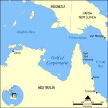
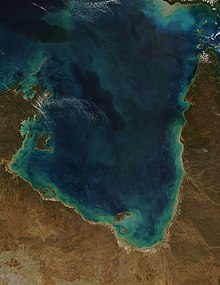
The Gulf of Carpentaria (/kɑːrpənˈtɛəriə/) is a sea off the northern coast of Australia. It is enclosed on three sides by northern Australia and bounded on the north by the eastern Arafura Sea, which separates Australia and New Guinea. The northern boundary is generally defined as a line from Slade Point, Queensland (the northwestern corner of Cape York Peninsula) in the northeast, to Cape Arnhem on the Gove Peninsula, Northern Territory (the easternmost point of Arnhem Land) in the west.
At its mouth, the Gulf is 590 km (370 mi) wide, and further south, 675 km (420 mi). The north-south length exceeds 700 km (430 mi). It covers a water area of about 300,000 km2 (120,000 sq mi). The general depth is between 55 and 66 metres (30 and 36 fathoms) [1] with a maximum depth of 69 metres (38 fathoms).[2] The tidal range in the Gulf of Carpentaria is between two and three metres (6.5 and 10 ft).[3] The Gulf and adjacent Sahul Shelf were dry land at the peak of the last ice age 18,000 years ago when global sea level was around 120 m (390 ft) below its present position. At that time a large, shallow lake occupied the centre of what is now the Gulf.[4] The Gulf hosts a submerged coral reef province that was only recognised in 2004.[5]
- ^ "Sector 1: North Coast of Australia – Gulf of Carpentaria". Sailing Directions (enroute).: North, west, and south coasts of Australia. National Imagery and Mapping Agency. 2001. p. 3. Retrieved 6 October 2020. or Sector 1: North Coast of Australia – Gulf of Carpentaria
- ^ T. Torgersen, M. R. Jones, A. W. Stephens, D. E. Searle & W. J. Ullman. Late Quaternary hydrological changes in the Gulf of Carpentaria. Nature Volume 313 pages 785-787 (1985)
- ^ Cite error: The named reference
ewclwas invoked but never defined (see the help page). - ^ Torgersen, T., Hutchinson, M.F., Searle, D.E., Nix, H.A., 1983. General bathymetry of the Gulf of Carpentaria and the Quaternary physiography of Lake Carpentaria. Palaeogeogr., Palaeoclimatol., Palaeoecol. 41, 207-225
- ^ Harris, P.T., Heap, A.D., Marshall, J.F., McCulloch, M.T., 2008. A new coral reef province in the Gulf of Carpentaria, Australia: colonisation, growth and submergence during the early Holocene. Marine Geology 251, 85-97.