Back مقاطعة هاوارد (آيوا) Arabic Howard County, Iowa BAR Хауърд (окръг, Айова) Bulgarian হাৱার্ড কাউন্টি, আইৱা BPY Howard Gông (Iowa) CDO Хауард (гуо, Айова) CE Howard County (kondado sa Tinipong Bansa, Iowa) CEB Howard County, Iowa Welsh Howard County (Iowa) German Κομητεία Χάουαρντ (Άιοβα) Greek
Howard County | |
|---|---|
 | |
 Location within the U.S. state of Iowa | |
 Iowa's location within the U.S. | |
| Coordinates: 43°21′27″N 92°18′56″W / 43.3575°N 92.315555555556°W | |
| Country | |
| State | |
| Founded | 1851 |
| Named for | Tilghman Howard |
| Seat | Cresco |
| Largest city | Cresco |
| Area | |
• Total | 474 sq mi (1,230 km2) |
| • Land | 473 sq mi (1,230 km2) |
| • Water | 0.4 sq mi (1 km2) 0.08% |
| Population (2020) | |
• Total | 9,469 |
| • Density | 20/sq mi (7.7/km2) |
| Time zone | UTC−6 (Central) |
| • Summer (DST) | UTC−5 (CDT) |
| Congressional district | 1st |
| Website | howardcounty |
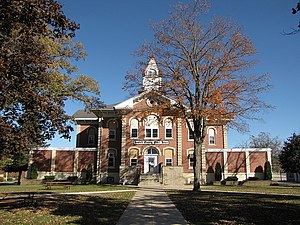
Howard County is a county located in the US state of Iowa. As of the 2020 census, the population was 9,469.[1] The county seat is Cresco.[2] The county was founded in 1851; it was named for General Tilghman Ashurst Howard, a Representative of Indiana.[3][4]
- ^ "2020 Census State Redistricting Data". census.gov. United states Census Bureau. Retrieved August 12, 2021.
- ^ "Find a County". National Association of Counties. Archived from the original on May 31, 2011. Retrieved June 7, 2011.
- ^ "Howard County, Iowa - History". Howard County, Iowa. Retrieved March 6, 2014.
- ^ Gannett, Henry (1905). The Origin of Certain Place Names in the United States. Govt. Print. Off. p. 162.