Back هوريكان Arabic هوريكان (بوتنام) ARZ Hurricane (Virgínia de l'Oest) Catalan Гаррикейн (Малхбузен Вирджини) CE Hurricane (lungsod sa Tinipong Bansa, West Virginia) CEB Hurricane, Gorllewin Virginia Welsh Hurricane (Virginia Occidental) Spanish Hurricane (Mendebaldeko Virginia) Basque هریکین، ویرجینیای غربی Persian Hurricane (Virginie-Occidentale) French
Hurricane, West Virginia | |
|---|---|
 Main Street in Hurricane in 2007 | |
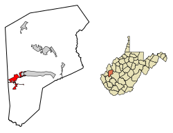
 Location of Hurricane in Putnam County, West Virginia. | |
| Coordinates: 38°25′57″N 82°1′11″W / 38.43250°N 82.01972°W | |
| Country | United States |
| State | West Virginia |
| County | Putnam |
| Government | |
| • Type | Mayor-Council |
| • Mayor | Scott Edwards |
| Area | |
• Total | 3.78 sq mi (9.78 km2) |
| • Land | 3.74 sq mi (9.70 km2) |
| • Water | 0.03 sq mi (0.08 km2) |
| Elevation | 705 ft (215 m) |
| Population | |
• Total | 6,977 |
• Estimate (2021)[2] | 6,919 |
| • Density | 1,717.41/sq mi (663.15/km2) |
| Time zone | UTC-5 (Eastern (EST)) |
| • Summer (DST) | UTC-4 (EDT) |
| ZIP code | 25526 |
| Area code(s) | 304, 681 |
| FIPS code | 54-39532[3] |
| GNIS feature ID | 1554759[4] |
| Website | http://www.hurricanewv.com/ |
Hurricane (/ˈhɜːrʌkɪn/ HUR-uh-kin)[a] is a city in Putnam County, West Virginia, United States. The population was 6,977 at the 2020 census.[2] Located roughly equidistant from Charleston and Huntington, it is part of the Huntington–Ashland metropolitan area.
- ^ "2019 U.S. Gazetteer Files". United States Census Bureau. Retrieved August 7, 2020.
- ^ a b c "City and Town Population Totals: 2020-2021". Census.gov. US Census Bureau. Retrieved July 3, 2022.
- ^ "U.S. Census website". United States Census Bureau. Retrieved January 31, 2008.
- ^ "US Board on Geographic Names". United States Geological Survey. October 25, 2007. Retrieved January 31, 2008.
- ^ Kirk, Sam (January 4, 2022). "West Virginia place names you might be saying wrong". WBOY-TV. Clarksburg, West Virginia. Retrieved April 21, 2023.
Cite error: There are <ref group=lower-alpha> tags or {{efn}} templates on this page, but the references will not show without a {{reflist|group=lower-alpha}} template or {{notelist}} template (see the help page).
