| Ilfracombe Queensland | |||||||||||||||
|---|---|---|---|---|---|---|---|---|---|---|---|---|---|---|---|
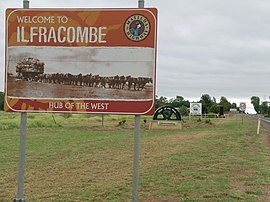
 Town entry signs | |||||||||||||||
| Coordinates | 23°29′26″S 144°30′34″E / 23.4905°S 144.5094°E | ||||||||||||||
| Population | 310 (2021 census)[1] | ||||||||||||||
| • Density | 0.0472/km2 (0.1221/sq mi) | ||||||||||||||
| Established | 1891 | ||||||||||||||
| Postcode(s) | 4727 | ||||||||||||||
| Elevation | 214 m (702 ft) | ||||||||||||||
| Area | 6,573.3 km2 (2,538.0 sq mi) | ||||||||||||||
| Time zone | AEST (UTC+10:00) | ||||||||||||||
| Location |
| ||||||||||||||
| LGA(s) | Longreach Region | ||||||||||||||
| State electorate(s) | Gregory | ||||||||||||||
| Federal division(s) | Maranoa | ||||||||||||||
| |||||||||||||||
Ilfracombe /ˈɪlfrəkoʊm/ is a rural town and locality in the Longreach Region, Queensland, Australia.[2][3] In the 2021 census, the locality of Ilfracombe had a population of 310 people.[1]
Ilfracombe calls itself The Hub of the West. The main industry is sheep rearing, mainly for wool.
- ^ a b Cite error: The named reference
Census2021was invoked but never defined (see the help page). - ^ "Ilfracombe – town in Longreach Region (entry 16618)". Queensland Place Names. Queensland Government. Retrieved 20 July 2021.
- ^ "Ilfracombe – locality in Longreach Region (entry 50309)". Queensland Place Names. Queensland Government. Retrieved 20 July 2021.

