Back ایتری AZB Itri BCL Итри Bulgarian Itri Breton Itri (municipi) Catalan Итри CE Itri (munisipyo) CEB Itri German Itri Esperanto Itri Spanish
Itri | |
|---|---|
| Comune di Itri | |
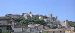
 Panorama of the Città alta of Itri, with the castle on the right. | |
| Coordinates: 41°17′N 13°32′E / 41.283°N 13.533°E | |
| Country | Italy |
| Region | Lazio |
| Province | Latina (LT) |
| Government | |
| • Mayor | Giovanni Agresti |
| Area | |
• Total | 101 km2 (39 sq mi) |
| Elevation | 170 m (560 ft) |
| Population (31 July 2021)[2] | |
• Total | 10,342 |
| • Density | 100/km2 (270/sq mi) |
| Demonym | Itrani |
| Time zone | UTC+1 (CET) |
| • Summer (DST) | UTC+2 (CEST) |
| Postal code | 04020 |
| Dialing code | 0771 |
| Patron saint | Madonna della Civita |
| Saint day | July 21 |
| Website | Official website |
Itri is a small city and comune the province of Latina, Lazio, central Italy.
Itri is an agricultural centre divided in two parts by a small river, the Pontone. It lies in a valley between the Monti Aurunci and the sea, not far from the Gulf of Gaeta. The more ancient part, with the Castle, was partly destroyed during World War II.
The Itrani speak a particular variant of the Neapolitan language called Itrano.
- ^ "Superficie di Comuni Province e Regioni italiane al 9 ottobre 2011". Italian National Institute of Statistics. Retrieved 16 March 2019.
- ^ "Popolazione Residente al 1° Gennaio 2018". Italian National Institute of Statistics. Retrieved 16 March 2019.


