Back مقاطعة كينغز (كاليفورنيا) Arabic Kinqs qraflığı (Kaliforniya) Azerbaijani Kings County, Kalifornien BAR Кінгс (акруга) Byelorussian Кингс Bulgarian কিংস কাউন্টি, ক্যালিফোর্নিয়া BPY Comtat de Kings (Califòrnia) Catalan Кингс (гуо, Калифорни) CE Kings County (kondado sa Tinipong Bansa, California) CEB ناوچەی کینگس (کالیفۆرنیا) CKB
Kings County, California | |
|---|---|
| County of Kings | |
 | |
 Interactive map of Kings County | |
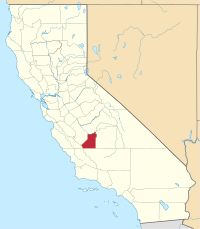
 Location in the state of California | |
| Coordinates: 36°04′N 119°49′W / 36.07°N 119.81°W | |
| Country | United States |
| State | California |
| Region | San Joaquin Valley |
| Metropolitan area | Hanford-Corcoran |
| Established | March 22, 1893[1] |
| Named for | Kings River |
| County seat | Hanford |
| Largest city | Hanford (population) Avenal (area) |
| Incorporated cities | 4 |
| Government | |
| • Type | Council–CAO |
| • Body | Board of Supervisors |
| • Chair | Richard Fagundes |
| • Vice Chair | Doug Verboon |
| • Board of Supervisors[2] | Supervisors
|
| • County Administrative Officer | Edward Hill |
| Area | |
• Total | 1,392 sq mi (3,610 km2) |
| • Land | 1,389 sq mi (3,600 km2) |
| • Water | 2.1 sq mi (5 km2) |
| Highest elevation | 3,476 ft (1,059 m) |
| Population (2020) | |
• Total | 152,486 |
| • Density | 110/sq mi (42/km2) |
| GDP | |
| • Total | $8.146 billion (2022) |
| Time zone | UTC−8 (Pacific Time Zone) |
| • Summer (DST) | UTC−7 (Pacific Daylight Time) |
| Area code | 559 |
| FIPS code | 06-031 |
| GNIS feature ID | 277280 |
| Congressional districts | 20th, 22nd |
| Website | countyofkings.com |
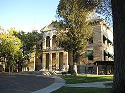
Kings County is a county located in the U.S. state of California. The population was 152,486 at the 2020 census.[5] The county seat is Hanford.[6]
Kings County comprises the Hanford-Corcoran, CA metropolitan statistical area, which is also included in the Visalia-Porterville-Hanford, CA combined statistical area. It is in the San Joaquin Valley, a rich agricultural region.
- ^ "Kings County". Geographic Names Information System. United States Geological Survey, United States Department of the Interior.
- ^ "Board of Supervisors | Kings County".
- ^ Table Mountain
- ^ "Gross Domestic Product: All Industries in Kings County, CA". Federal Reserve Economic Data. Federal Reserve Bank of St. Louis.
- ^ "Kings County, California". United States Census Bureau. Retrieved January 30, 2022.
- ^ "Find a County". National Association of Counties. Archived from the original on May 31, 2011. Retrieved June 7, 2011.

