| Kirup Western Australia | |||||||||||||||
|---|---|---|---|---|---|---|---|---|---|---|---|---|---|---|---|
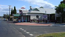
 Kirup Tavern and Deli | |||||||||||||||
 | |||||||||||||||
| Coordinates | 33°42′29″S 115°53′38″E / 33.708°S 115.894°E | ||||||||||||||
| Population | 156 (SAL 2021)[1] | ||||||||||||||
| Established | 1901 | ||||||||||||||
| Postcode(s) | 6251 | ||||||||||||||
| Elevation | 194 m (636 ft) | ||||||||||||||
| Area | 76.9 km2 (29.7 sq mi) | ||||||||||||||
| Location | |||||||||||||||
| LGA(s) | Shire of Donnybrook-Balingup | ||||||||||||||
| State electorate(s) | Collie-Preston | ||||||||||||||
| Federal division(s) | Forrest | ||||||||||||||
| |||||||||||||||
Kirup, originally named Upper Capel, then Kirupp, is situated between Donnybrook and Balingup on the South Western Highway, 228 kilometres (142 mi) south of Perth, Western Australia in the upper reaches of the Capel River valley.
Kirup is one of the three main town sites within the Shire of Donnybrook-Balingup.
- ^ Australian Bureau of Statistics (28 June 2022). "Kirup (suburb and locality)". Australian Census 2021 QuickStats. Retrieved 28 June 2022.

