Back مقاطعة لامباساس (تكساس) Arabic لامپاساس بؤلگهسی، تکزاس AZB Lampasas County, Texas BAR Лампасас (акруга) Byelorussian Лампасас (окръг, Тексас) Bulgarian লামপাস কাউন্টি, টেক্সাস BPY Lampasas Gông (Texas) CDO Lampasas County CEB Lampasas County Czech Lampasas County, Texas Welsh
Lampasas County | |
|---|---|
 The Lampasas County Courthouse was completed in 1884. The structure was added to the National Register of Historic Places on June 21, 1971. | |
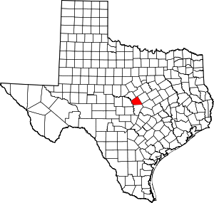
 Location within the U.S. state of Texas | |
 Texas's location within the U.S. | |
| Coordinates: 31°11′N 98°14′W / 31.19°N 98.24°W | |
| Country | |
| State | |
| Founded | 1856 |
| Named for | Lampasas River |
| Seat | Lampasas |
| Largest city | Lampasas |
| Area | |
• Total | 714 sq mi (1,850 km2) |
| • Land | 713 sq mi (1,850 km2) |
| • Water | 1.1 sq mi (3 km2) 0.2% |
| Population (2020) | |
• Total | 21,627 |
| • Density | 30/sq mi (12/km2) |
| Time zone | UTC−6 (Central) |
| • Summer (DST) | UTC−5 (CDT) |
| Congressional district | 11th |
| Website | www |
Lampasas County (/læmˈpæsəs/ lam-PASS-əs) is a county located on the Edwards Plateau in the U.S. state of Texas. As of the 2020 census, its population was 21,627.[1] Its county seat is Lampasas.[2] The county is named for the Lampasas River.
Lampasas County is part of the Killeen–Temple metropolitan statistical area.
- ^ "Lampasas County, Texas". United States Census Bureau. Retrieved February 23, 2021.
- ^ "Find a County". National Association of Counties. Retrieved June 7, 2011.