Back لیلین، آلاباما AZB Lillian, Alabama Welsh Lillian Spanish لیلین، آلاباما Persian لیلیان (آلاباما) GLK Lillian (Alabama) HT Lillian (Alabama) LLD 莉蓮 (阿拉巴馬州) Chinese
Lillian, Alabama | |
|---|---|
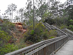
 County park at Lillian, Alabama | |
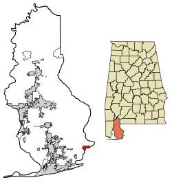
 Location of Lillian in Baldwin County, Alabama. | |
| Coordinates: 30°24′47″N 87°26′13″W / 30.41306°N 87.43694°W | |
| Country | United States |
| State | Alabama |
| County | Baldwin |
| Government | |
| • Type | Baldwin Cty. Lillian is unincorporated |
| Area | |
• Total | 3.53 sq mi (9.14 km2) |
| • Land | 1.91 sq mi (4.94 km2) |
| • Water | 1.62 sq mi (4.20 km2) |
| Population (2020) | |
• Total | 1,330 |
| • Density | 696.70/sq mi (268.96/km2) |
| Time zone | UTC-6 (Central (CST)) |
| • Summer (DST) | UTC-5 (CDT) |
| ZIP code | 36549[2] |
| Area code | 251 |
| FIPS code | 01-42928 |
| GNIS feature ID | 2633315 |
Lillian is an unincorporated community and census-designated place in eastern Baldwin County, Alabama, United States. Lillian is located on U.S. Route 98 on the western shore of Perdido Bay, 9.5 miles (15.3 km) east of Elberta. Its eastern edge lies on the Alabama/Florida state line.
- ^ "2020 U.S. Gazetteer Files". United States Census Bureau. Retrieved October 29, 2021.
- ^ "Lillian AL ZIP Code". zipdatamaps.com. 2023. Retrieved January 26, 2023.

