Back Lisianski Catalan Lisianski Island CEB Lisjanského ostrov Czech Lisianski German Insulo Lisianski Esperanto Lisianski Spanish Lisianski Basque جزیره لیسیانسکی Persian Île Lisianski French Lisianski Galician
Native name: Papa‘āpoho | |
|---|---|
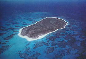
 View of Lisianski from the air. | |
| Geography | |
| Location | Pacific Ocean |
| Coordinates | 26°03′51″N 173°57′57″W / 26.064031°N 173.965802°W |
| Archipelago | Northwestern Hawaiian Islands |
| Area | 384.425 acres (155.571 ha) |
| Length | 1.2 mi (1.9 km) |
| Width | 0.6 mi (1 km) |
| Coastline | 3.1 mi (5 km) |
| Administration | |
| State | Hawaii |
Lisianski Island (Hawaiian: Papa‘āpoho) is one of the Northwestern Hawaiian Islands, with a land area of 384.425 acres (155.571 ha) and a maximum elevation of 40 feet (12 m) above sea level. It is a low, flat sand and coral island about 905 nautical miles (1,041 mi; 1,676 km) northwest of Honolulu, Hawaii.[1] The island is surrounded by reefs and shoals, including the extensive Neva Shoals. Access to the island is possible only by helicopter or by boat via a narrow sandy inlet on the southeastern side of the island.
