Back قائمة الغابات الوطنية للولايات المتحدة Arabic Llista de boscos nacionals dels Estats Units Catalan Anexo:Bosques del sistema nacional de bosques de los Estados Unidos Spanish Liste des forêts nationales aux États-Unis French Foreste nazionali degli Stati Uniti d'America Italian Lijst van gebieden in het National Forest System van de Verenigde Staten Dutch Список национальных лесов США Russian Список національних лісів США Ukrainian 美国国家森林列表 Chinese

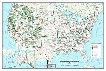
The United States has 154 protected areas known as national forests, covering 188,336,179 acres (762,169 km2; 294,275 sq mi).[1] National forests are managed by the U.S. Forest Service, an agency of the U.S. Department of Agriculture.[2] The first national forest was established as the Yellowstone Park Timber and Land Reserve on March 30, 1891, then in the Department of the Interior. In 1897, the Organic Act provided purposes for which forest reserves could be established, including to reserve a supply of timber, protect the forest from development, and secure water supplies. With the Forest Reserve Act of 1891, the president of the United States is given the power to set aside forest reserves in the public domain. With the Transfer Act of 1905, forest reserves became part of the U.S. Department of Agriculture in the newly created U.S. Forest Service.[3][4]
By 1907, President Theodore Roosevelt had more than doubled the forest-reserve acreage, and Congress responded by limiting the president's ability to proclaim new reserves. The National Forest System underwent a major reorganization in 1908, and in 1911 Congress authorized new additions to the system under the authority of the Weeks Act. The management goals provided by the Organic Act were expanded upon by the Multiple-Use Sustained-Yield Act of 1960 to include "outdoor recreation, range, timber, watershed, and wildlife and fish purposes" as well as for the establishment of wilderness areas.[3][4]
As of September 30, 2014, the Forest Service manages a total of 192,922,127 acres (780,728.15 km2), 188,336,179 acres (762,169.48 km2) of which are national forests. The additional land areas include 20 national grasslands, 59 purchase units, 19 research and experimental areas, five land utilization projects and 37 other areas. The National Forest System has an extensive and complicated history of reorganization, so while there are currently 154 named national forests, many of these are managed together as either a single forest or separate forests.[A][1][4][5]
There is at least one national forest in all but ten states: Connecticut, Delaware, Hawaii, Iowa, Kansas, Maryland, Massachusetts, New Jersey, North Dakota, and Rhode Island (although Kansas and North Dakota have national grasslands). In addition, Puerto Rico contains El Yunque National Forest, the only tropical U.S. rainforest. Alaska has the most national forest land, with 21.9 million acres (8.9 million ha), followed by California (20.8 million acres, 8.4 million ha) and Idaho (20.4 million acres, 8.3 million ha). Idaho also has the greatest percent of its land in national forests, with 38.2 percent, followed by Oregon (24.7 percent) and Colorado (20.9 percent). On maps, national forests in the west generally show the true extent of their area, but those in the east often only show purchase districts, within which usually only a minority of the land is owned by the Forest Service.[1]
- ^ a b c Cite error: The named reference
Areaswas invoked but never defined (see the help page). - ^ "About the Agency". U.S. Forest Service. Archived from the original on February 25, 2013.
- ^ a b Gorte, Ross W.; Cody, Betsy A. (November 7, 1995). "The Forest Service and Bureau of Land Management: History and Analysis of Merger Proposals". Congressional Research Service Reports for Congress. Archived from the original on November 12, 2013. Retrieved October 22, 2012.
- ^ a b c Cite error: The named reference
Dateswas invoked but never defined (see the help page). - ^ "Find a Forest by State". U.S. Forest Service. Retrieved October 22, 2012.