Back Ланруст Bulgarian Llanrwst Breton Llanrwst (lungsod) CEB Llanrwst Welsh Llanrwst Danish Llanrwst Spanish Llanrwst Basque سانروست Persian Llanrwst French Llanrwst Irish
| Llanrwst | |
|---|---|
 | |
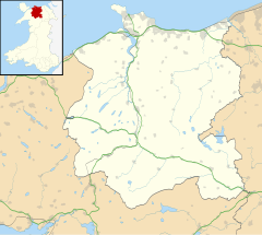
Location within Conwy | |
| Area | 5.24 km2 (2.02 sq mi) |
| Population | 3,323 [1] |
| • Density | 634/km2 (1,640/sq mi) |
| OS grid reference | SH800615 |
| Community |
|
| Principal area | |
| Preserved county | |
| Country | Wales |
| Sovereign state | United Kingdom |
| Post town | LLANRWST |
| Postcode district | LL26 |
| Dialling code | 01492 |
| Police | North Wales |
| Fire | North Wales |
| Ambulance | Welsh |
| UK Parliament | |
| Senedd Cymru – Welsh Parliament | |
Llanrwst (Welsh for 'church or parish of Saint Grwst'; Welsh pronunciation: [ɬanˈruːst]) is a market town and community on the A470 road and the River Conwy, in Conwy County Borough, Wales, and the historic county of Denbighshire. It developed around the wool trade and became known also for the making of harps and clocks.[3] Today, less than one mile (two kilometres) from the edge of Snowdonia,[4] its main pursuit is tourism. Notable buildings include almshouses, two 17th-century chapels, and the Parish Church of St Grwst, which holds the stone coffin of Llywelyn the Great. The 2011 census gave it a population of 3,323.
- ^ "Area: Llanrwst (Parish), Key Figures for 2011 Census: Key Statistics". Neighbourhood Statistics. Office for National Statistics. Retrieved 15 May 2014.
- ^ "Cyngor Llanrwst". Retrieved 3 May 2023.
- ^ "snowdoniaantiques.co.uk - Snowdonia Antiques. North Wales Fine Antique Furniture and Clock Specialists". snowdoniaantiques.co.uk.
- ^ Snowdonia National Park Authority. "Location Map". Archived from the original on 23 October 2014.

