Back Río Magdalena Afrikaans نهر ماجدالينا Arabic Ríu Magdalena AST Magdalena (kuksa) AVK Maqdalena çayı Azerbaijani ماقدالنا چایی AZB Магдалена (йылға) Bashkir Магдалена Byelorussian Магдалена (рака) BE-X-OLD Магдалена (река) Bulgarian
| Magdalena | |
|---|---|
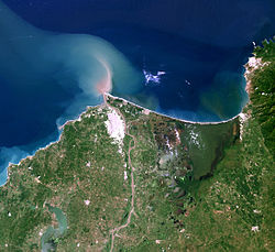
 The delta of the Magdalena River | |
 Map of the Magdalena River watershed | |
| Etymology | Biblical figure Mary Magdalene |
| Location | |
| Country | Colombia |
| Cities | |
| Physical characteristics | |
| Source | La Magdalena lagoon |
| • location | Colombian Massif, Colombia |
| • coordinates | 1°56′3″N 76°36′29″W / 1.93417°N 76.60806°W |
| • elevation | 3,685 m (12,090 ft) |
| Mouth | Caribbean Sea |
• location | Barranquilla, Colombia |
• coordinates | 11°7′0″N 74°51′0″W / 11.11667°N 74.85000°W |
• elevation | 0 m (0 ft) |
| Length | 1,528 km (949 mi)[1] |
| Basin size | 257,438 km2 (99,397 sq mi) to 271,807 km2 (104,945 sq mi)[2] |
| Discharge | |
| • location | Calamar, Bolívar[3] |
| • average | (Period: 1975–1995) 7,200 m3/s (250,000 cu ft/s)[3] (Period: 1991–2020) 8,058 m3/s (284,600 cu ft/s)[2] |
| • minimum | 2,000 m3/s (71,000 cu ft/s) |
| • maximum | 12,000 m3/s (420,000 cu ft/s) |
| Basin features | |
| Tributaries | |
| • left | Páez, Saldaña, La Miel, Nare, Cauca, San Jorge |
| • right | Cabrera, Bogotá, Negro, Carare, Sogamoso, Cesar |
| Official name | Sistema Delta Estuarino del Río Magdalena, Ciénaga Grande de Santa Marta |
| Designated | 18 June 1998 |
| Reference no. | 951[4] |
The Magdalena River (Spanish: Río Magdalena, Spanish pronunciation: [ˈri.o maɣðaˈlena]; less commonly Rio Grande de la Magdalena)[5] is the main river of Colombia, flowing northward about 1,528 kilometres (949 mi) through the western half of the country. It takes its name from the biblical figure Mary Magdalene. It is navigable through much of its lower reaches, in spite of the shifting sand bars at the mouth of its delta, as far as Honda, at the downstream base of its rapids. It flows through the Magdalena River Valley.
Its drainage basin covers a surface of 273,000 square kilometres (105,000 sq mi), which is 24% of the country's area and where 66% of its population lives.
- ^ "Sistema de informacion Ambiental de Colombia – SIAC" (in Spanish). Archived from the original on 2012-03-15. Retrieved 2011-07-13.
- ^ a b ESTUDIO NACIONAL DEL AGUA 2022 (PDF). 2023. ISBN 978-958-5489-12-7.
- ^ a b "Chapter 14" (PDF). The Pacific and Caribbean Rivers of Colombia: Water Discharge, Sediment Transport and Dissolved Loads. Archived from the original (PDF) on 2012-03-25. Retrieved 2011-07-13.
- ^ "Sistema Delta Estuarino del Río Magdalena, Ciénaga Grande de Santa Marta". Ramsar Sites Information Service. Retrieved 25 April 2018.
- ^ "Polinizaciones: Las Abejas y las Garzas / The Bees and Storks". Polinizaciones.blogspot.com. 7 February 2008. Retrieved 2008-11-06.