Back Mangoro (suba sa Madagaskar, lat -20,00, long 48,77) CEB Mangoro German Río Mangoro Spanish Mangoro (fleuve) French Mangoro Hungarian Mangoro Malagasy Mangoro Dutch Mangoro Polish Râul Mangoro Romanian Mangoro (Madagaskar) Serbo-Croatian
| Mangoro River | |
|---|---|
 Mangoro | |
 Mangoro River | |
| Native name | Mangoro (Malagasy) |
| Location | |
| Country | Madagascar |
| Physical characteristics | |
| Source | |
| • location | 14 km from Mandialaza, NE of Anjozorobe |
| • elevation | 1,100 m (3,600 ft) |
| Mouth | |
• location | Ambodiharina, Indian Ocean |
• coordinates | 20°0′17.8848″S 48°46′54.0192″E / 20.004968000°S 48.781672000°E |
• elevation | 0 m (0 ft) |
| Length | 300 km (190 mi)[1] |
| Basin size | 17,175 km2 (6,631 sq mi) |
| Discharge | |
| • location | Near mouth |
| • average | (Period: 1971–2000)386.3 m3/s (13,640 cu ft/s)[2] |
| Basin features | |
| River system | Mangoro River |
| Tributaries | |
| • right | Onive, Nosivolo |

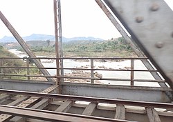
The Mangoro River is the largest river on the east coast of Madagascar by basin size and water volume, and is 300 km in length.[3]
- ^ Cite error: The named reference
missionwas invoked but never defined (see the help page). - ^ "Madagascar".
- ^ "Mangoro River (Madagascar)". LC Linked Data Service (Library of Congress). Retrieved 2013-03-05.