| Marcellus Formation | |
|---|---|
| Stratigraphic range: Middle Devonian | |
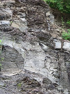
 Marcellus shale exposure above Marcellus, N.Y. The vertical joints create sheer cliff faces. | |
| Type | Geological formation |
| Unit of | Hamilton Group |
| Sub-units | See: Named members |
| Underlies | Mahantango Formation and Skaneatales Formation/Stafford Lime Mbr |
| Overlies | Huntersville Chert, Needmore Shale, and Onondaga Formation |
| Thickness | up to 900 feet (270 m)[1] |
| Lithology | |
| Primary | Shale |
| Other | Slate, limestone, sandstone, tuff |
| Location | |
| Region | Appalachian Basin of eastern North America |
| Extent | 600 miles (970 km)[2] |
| Type section | |
| Named for | Marcellus, New York |
| Named by | James Hall, 1839 |
The Marcellus Formation or the Marcellus Shale is a Middle Devonian age unit of sedimentary rock found in eastern North America. Named for a distinctive outcrop near the village of Marcellus, New York, in the United States,[3] it extends throughout much of the Appalachian Basin.[4][5][6]
The unit name usage by the U.S. Geological Survey (USGS) includes Marcellus Shale and Marcellus Formation.[7] The term "Marcellus Shale" is the preferred name throughout most of the Appalachian region, although the term "Marcellus Formation" is also acceptable within the State of Pennsylvania.[7] The unit was first described and named as the "Marcellus shales" by J. Hall in 1839.[8]
- ^ Cite error: The named reference
Whitewas invoked but never defined (see the help page). - ^ "Another Shale Making Seismic Waves". March 2008.
- ^ Cite error: The named reference
MGS1918was invoked but never defined (see the help page). - ^ Ryder, R.T., Swezey, C.S., Crangle, R.D., Jr., and Trippi, M.T., 2008, Geologic cross section E-E’ through the central Appalachian Basin from the Findlay Arch, Wood County, Ohio, to the Valley and Ridge Province, Pendleton County, West Virginia: U.S. Geological Survey Scientific Investigations Map SIM-2985, 2 sheets with 48-page pamphlet. https://pubs.er.usgs.gov/publication/sim2985
- ^ Ryder, R.T., Crangle, R.D., Jr., Trippi, M.H., Swezey, C.S., Lentz, E.E., Rowan, E.L., and Hope, R.S., 2009, Geologic cross section D-D’ through the central Appalachian basin from the Findlay arch, Sandusky County, Ohio, to the Valley and Ridge province, Hardy County, West Virginia: U.S. Geological Survey Scientific Investigations Map SIM-3067, 2 sheets with 52-page pamphlet. https://pubs.er.usgs.gov/publication/sim3067
- ^ Ryder, R.T., Trippi, M.H., Swezey, C.S., Crangle, R.D., Jr., Hope, R.S., Rowan, E.L., and Lentz, E.E., 2012, Geologic cross section C-C’ through the central Appalachian basin from near the Findlay Arch, north-central Ohio, to the Valley and Ridge Province, Bedford County, south-central Pennsylvania: U.S. Geological Survey Scientific Investigations Map SIM-3172, 2 sheets with 70-page pamphlet. https://pubs.er.usgs.gov/publication/sim3172
- ^ a b See unit names marked by an asterisk at Geolex
- ^ New York Geological Survey, 3rd Report, p. 295-296
