Back مقاطعة ماسون (واشنطن) Arabic Mason County, Washington BAR Мейсън (окръг, Вашингтон) Bulgarian মেশন কাউন্টি, ৱাশিংটন BPY Mason Gông (Washington) CDO Мейсон (гуо, Вашингтон) CE Mason County (kondado sa Tinipong Bansa, Washington) CEB Mason County (Washington) Czech Mason County, Washington Welsh Mason County (Washington) German
Mason County | |
|---|---|
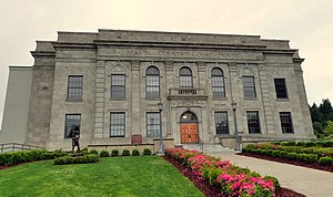
 Mason County Courthouse | |
 Location within the U.S. state of Washington | |
 Washington's location within the U.S. | |
| Coordinates: 47°21′N 123°11′W / 47.35°N 123.18°W | |
| Country | |
| State | |
| Founded | March 13, 1854 |
| Named for | Charles H. Mason |
| Seat | Shelton |
| Largest city | Shelton |
| Area | |
• Total | 1,051 sq mi (2,720 km2) |
| • Land | 959 sq mi (2,480 km2) |
| • Water | 92 sq mi (240 km2) 8.7% |
| Population (2020) | |
• Total | 65,726 |
• Estimate (2023) | 68,389 |
| • Density | 63/sq mi (24/km2) |
| Time zone | UTC−8 (Pacific) |
| • Summer (DST) | UTC−7 (PDT) |
| Congressional district | 6th |
| Website | masoncountywa.gov |
Mason County is a county located in the U.S. state of Washington. As of the 2020 census, the population was 65,726.[1] The county seat and only incorporated city is Shelton.[2] The county was formed out of Thurston County on March 13, 1854.[3] Originally named Sawamish County, it took its present name in 1864 in honor of Charles H. Mason, the first Secretary of Washington Territory.[3][4]
Mason County comprises the Shelton micropolitan statistical area and is included in the Seattle-Tacoma combined statistical area.

- ^ "State & County QuickFacts". United States Census Bureau. Retrieved November 9, 2024.
- ^ "Find a County". National Association of Counties. Retrieved June 7, 2011.
- ^ a b Wilma, David (April 30, 2006). "Mason County — Thumbnail History". HistoryLink. Retrieved May 27, 2019.
- ^ Washington Agricultural Statistics Service, US Department of Agriculture, as archived at the Internet Archive
