Back نهر ماتانوسكا ARZ Riu Matanuska Catalan Matanuska River CEB Matanuska Czech Matanuska River German Río Matanuska Spanish Matanuska (rivière) French מטנוסקה (נהר) HE Matanuska Italian მატანუსკა Georgian
| Matanuska River | |
|---|---|
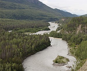
 Silt-laden waters of the Chickaloon River (right center) enter the Matanuska River at mile 76 (km 123) of the Glenn Highway (upper right), a major highway connecting Anchorage to the rest of the state. The valley is forested with black cottonwood, balsam poplar, white spruce and paper birch. | |
 South-central Alaska, near Anchorage | |
| Native name | Ch'atanhtnu (Tanaina) |
| Location | |
| Country | United States |
| State | Alaska |
| Borough | Matanuska-Susitna |
| Physical characteristics | |
| Source | confluence of the river's east and south forks |
| • coordinates | 61°47′27″N 147°29′07″W / 61.79083°N 147.48528°W[1] |
| • elevation | 2,033 ft (620 m)[2] |
| Mouth | Knik Arm, Cook Inlet |
• location | 9.5 miles (15.3 km) southwest of Palmer |
• coordinates | 61°29′49″N 149°16′11″W / 61.49694°N 149.26972°W[1] |
• elevation | 0 ft (0 m)[1] |
| Length | 75 mi (121 km)[3] |
| Basin size | 2,100 sq mi (5,400 km2)[4] |
| Discharge | |
| • location | Palmer[5] |
| • average | 3,875 cu ft/s (109.7 m3/s)[5] |
| • minimum | 234 cu ft/s (6.6 m3/s) |
| • maximum | 82,100 cu ft/s (2,320 m3/s) |
The Matanuska River (Dena'ina: Ch'atanhtnu; Ahtna: Ts'itonhna’) is a 75-mile (121 km) long river in Southcentral Alaska, United States.[3] The river drains a broad valley south of the Alaska Range eponymously known as the Matanuska Valley.[6]
- ^ a b c "Matanuska River". Geographic Names Information System. United States Geological Survey. March 31, 1981. Retrieved December 5, 2013.
- ^ Derived by entering source coordinates in Google Earth.
- ^ a b Orth, Donald J.; United States Geological Survey (1971) [1967]. Dictionary of Alaska Place Names: Geological Survey Professional Paper 567 (PDF). United States Government Printing Office. p. 628. Archived from the original (PDF) on October 17, 2013. Retrieved December 5, 2013.
- ^ Curran, J. H.; McTeague, M. L. (2011). "Geomorphology and Bank Erosion of the Matanuska River, Southcentral Alaska: Scientific Investigations Report 2011–5214" (PDF). U.S. Geological Survey. pp. 1–5. Retrieved December 5, 2013.
- ^ a b "USGS 15284000 Matanuska River at Palmer, Alaska". United States Geological Survey. Retrieved December 6, 2013.
- ^ Alaska Atlas & Gazetteer (7th ed.). Yarmouth, Maine: DeLorme. 2010. pp. 83–84. ISBN 978-0-89933-289-5.
