Back دلتا ميكونغ Arabic Mekonq deltası Azerbaijani دلتای رود مکونق AZB Дэльта Меконга Byelorussian Делта на Меконг Bulgarian মেকং ব-দ্বীপ Bengali/Bangla Delta del Mekong Catalan Mekong Delta CEB Mekongdelta German Delto de la Mekonga Rivero Esperanto
Mekong Delta
Đồng bằng Sông Cửu Long Đồng Bằng Sông Mê Kông | |
|---|---|
 Rice paddy in the Mekong River Delta. | |
| Nickname(s): "Nine Dragon river delta", "The West" | |
 Provincial map | |
| Coordinates: 10°02′N 105°48′E / 10.04°N 105.80°E | |
| Country | |
| Area | |
• Total | 43,000 km2 (17,000 sq mi) |
| Population (2022)[1] | |
• Total | 19,000,000 |
| • Density | 440/km2 (1,100/sq mi) |
| GDP | |
| • Total | VND 823 trillion US$ 36.2 billion (2021) |
| Time zone | UTC+07:00 (ICT) |
| HDI (2022) | 0.684[3] high · 5th |
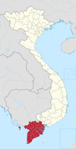
The Mekong Delta (Vietnamese: Đồng bằng Sông Cửu Long, lit. 'Nine Dragon River Delta' or simply Đồng Bằng Sông Mê Kông, 'Mekong River Delta'), also known as the Western Region (Vietnamese: Miền Tây) or South-western region (Vietnamese: Tây Nam Bộ), is the region in southwestern Vietnam where the Mekong River approaches and empties into the sea through a network of distributaries. The Mekong delta region encompasses a large portion of south-western Vietnam of over 40,500 km2 (15,600 sq mi).[4] The size of the area covered by water depends on the season. Its wet coastal geography makes it an important source of agriculture and aquaculture for the country.
The delta has been occupied as early as the 4th century BC. As a product of Khmer, Vietnamese, Chinese, and French settlement in the region, the delta and its waterways have numerous names, including the Khmer term Bassac to refer to the lower basin and the largest river branch flowing through it.[5] After the 1954 Geneva Conference, Vietnam was split into two[6] with South Vietnam inheriting the southern half of Vietnam becoming the State of Vietnam and eventually the Republic of Vietnam, also known as South Vietnam, with their own administrative states (see Category:Provinces of South Vietnam). After 1975, the Mekong Delta ceased being a part of the Republic of Vietnam, succeeded by the current Vietnamese nation. Today, the region comprises 12 provinces: Long An, Đồng Tháp, Tiền Giang, An Giang, Bến Tre, Vĩnh Long, Trà Vinh, Hậu Giang, Kiên Giang, Sóc Trăng, Bạc Liêu, and Cà Mau, along with the province-level municipality of Cần Thơ.
The Mekong Delta has been dubbed a 'biological treasure trove'. Over 1,000 animal species were recorded between 1997 and 2007 and new species of plants, fish, lizards, and mammals have been discovered in previously unexplored areas, including the Laotian rock rat, thought to be extinct.[7] The low-lying coastal geography of the region makes it vulnerable to climate change caused sea level rise, alongside related issues such as coastal erosion and saltwater intrusion.
- ^ a b Cite error: The named reference
gsowas invoked but never defined (see the help page). - ^ Cite error: The named reference
monrewas invoked but never defined (see the help page). - ^ "Sub-national HDI - Area Database - Global Data Lab". hdi.globaldatalab.org.
- ^ Mekong Delta Archived September 21, 2012, at the Wayback Machine on ARCBC (ASEAN Regional Centre for Biodiversity Conservation) site
- ^ Brocheux, Pierre (1995). The Mekong Delta: Ecology, Economy, and Revolution, 1860-1960. Center for Southeast Asian Studies, University of Wisconsin-Madison. p. 1.
- ^ Turner, Robert F. (1975). Vietnamese Communism: Its Origin and Development. Hoover Institution Press.
- ^ Ashley Fantz, "Mekong a 'treasure trove' of 1,000 newly discovered species Archived November 7, 2012, at the Wayback Machine", CNN. December 16, 2008.