Back مقاطعة ميرسير (كنتاكي) Arabic Mercer County, Kentucky BAR Мърсър (окръг, Кентъки) Bulgarian মারর্সের কাউন্টি, কেন্টাকি BPY Mercer Gông (Kentucky) CDO Мерсер (гуо, Кентукки) CE Mercer County (kondado sa Tinipong Bansa, Kentucky) CEB Mercer County (Kentucky) Czech Mercer County, Kentucky Welsh Mercer County (Kentucky) German
Mercer County | |
|---|---|
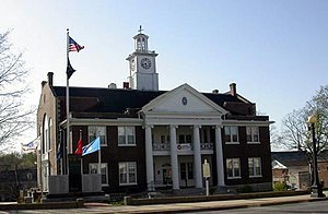
 Mercer County Courthouse in Harrodsburg | |
 Location within the U.S. state of Kentucky | |
 Kentucky's location within the U.S. | |
| Coordinates: 37°48′N 84°53′W / 37.8°N 84.88°W | |
| Country | |
| State | |
| Founded | 1785 |
| Named for | Hugh Mercer |
| Seat | Harrodsburg |
| Largest city | Harrodsburg |
| Area | |
• Total | 253 sq mi (660 km2) |
| • Land | 249 sq mi (640 km2) |
| • Water | 4.5 sq mi (12 km2) 1.8% |
| Population (2020) | |
• Total | 22,641 |
• Estimate (2023) | 23,097 |
| • Density | 89/sq mi (35/km2) |
| Time zone | UTC−5 (Eastern) |
| • Summer (DST) | UTC−4 (EDT) |
| Congressional district | 2nd |
| Website | www |
Mercer County is a county located in the central part of the U.S. Commonwealth of Kentucky. As of the 2020 census, the population was 23,772.[1] Its county seat is Harrodsburg.[2] The county was formed from Lincoln County, Virginia in 1785[3] and is named for Revolutionary War General Hugh Mercer, who was killed at the Battle of Princeton in 1777.[4] It was formerly a prohibition or dry county.
- ^ "State & County QuickFacts". United States Census Bureau. Retrieved September 4, 2022.
- ^ "Find a County". National Association of Counties. Retrieved June 7, 2011.
- ^ Collins, Lewis (1882). Collins' Historical Sketches of Kentucky: History of Kentucky, Volume 2. Collins & Company. p. 26.
- ^ The Register of the Kentucky State Historical Society, Volume 1. Kentucky State Historical Society. 1903. pp. 36.