Back نهر القاش Arabic Riu Mareb Catalan Mereb Wenz (suba, lat 14,88, long 37,87) CEB Mareb Czech Mareb Danish Mareb German Río Mareb Spanish Mareb (rivière) French Mareb Croatian Mareb Italian
| Mereb River Gash or al-Qash | |
|---|---|
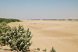
 The Mereb's dry riverbed at Kassala | |
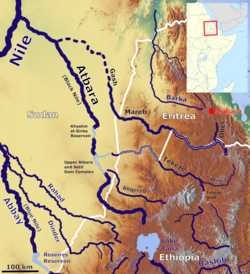
 The Mereb River in the Atbara basin | |
| Location | |
| Countries | |
| Physical characteristics | |
| Source | |
| • location | 15 kilometres (9.3 mi) south-west Asmara |
| Mouth | |
• location | Dissipates in the sands of the eastern Sudanese plains |
| Length | 440 km (270 mi) |
| Basin size | 31,000 km2 (12,000 sq mi) |
| Discharge | |
| • average | 21.6 m3/s (760 cu ft/s) |
| Basin features | |
| Tributaries | |
| • left | Sarana River, Balasa River, 'Engweya River, Gala River |
| • right | Obel River |
The Mareb River (Italian: fiume Mareb), also known as the Gash River (Arabic: القاش), is a river flowing out of central Eritrea. Its chief importance is defining part of the boundary between Eritrea and Ethiopia, between the point where the Mai Ambassa enters the river at 14°53.6′N 37°54.8′E / 14.8933°N 37.9133°E to the confluence of the Balasa with the Mareb at 14°38′N 39°1.3′E / 14.633°N 39.0217°E.[1]