Back Mole Valley CEB Ardal Mole Valley Welsh Mole Valley German Mole Valley Spanish Mole Valley French Mole Valley Italian 몰밸리 Korean Molveli Latvian/Lettish Mole Valley Dutch Mole Valley NB
Mole Valley District | |
|---|---|
 Bridge over the River Mole at Leatherhead | |
| Motto(s): Ministrando vigilans (Latin: Vigilant in our serving) | |
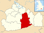
 Mole Valley shown within Surrey | |
| Sovereign state | United Kingdom |
| Constituent country | England |
| Region | South East England |
| Non-metropolitan county | Surrey |
| Status | Non-metropolitan district |
| Admin HQ | Dorking |
| Incorporated | 1 April 1974 |
| Government | |
| • Type | Non-metropolitan district council |
| • Body | Mole Valley District Council |
| Area | |
• Total | 99.7 sq mi (258.3 km2) |
| • Rank | 133rd (of 296) Highest point : Leith Hill |
| Population (2022) | |
• Total | 87,769 |
| • Rank | 271st (of 296) |
| • Density | 880/sq mi (340/km2) |
| Ethnicity (2021) | |
| • Ethnic groups | |
| Religion (2021) | |
| • Religion | List
|
| Time zone | UTC0 (GMT) |
| • Summer (DST) | UTC+1 (BST) |
| ONS code | 43UE (ONS) E07000210 (GSS) |
| OS grid reference | TQ0496458567 |
Mole Valley is a local government district in Surrey, England. Its council is based in Dorking, and the district's other town is Leatherhead. The largest villages are Ashtead, Fetcham and Great Bookham, in the northern third of the district.
Most of the district is on the escarpments of or adjoins the Surrey Hills, a designated Area of Outstanding Natural Beauty, which cover parts of the North Downs and Greensand Ridge, including locally Leith Hill, Polesden Lacey and Box Hill. Denbies Wine Estate, the largest vineyard in the country, is on the hills north-west of Dorking.[2] The Pilgrims' Way footpath runs along the North Downs. There are stations on the London–Worthing and Reading–Gatwick Airport railways, and in the northern third, a commuter stopping-service pattern line, London–Guildford (via Epsom) line.
The A24 road and the M25 motorway are the main thoroughfares and relative to London the incidence of car ownership is high. The area hosts hill-focussed sub-laps of the London–Surrey Classic cycling tour each year.
The neighbouring districts are Epsom and Ewell, Reigate and Banstead, Crawley, Horsham, Waverley, Guildford, Elmbridge and Kingston upon Thames, the latter being a London borough.
- ^ a b UK Census (2021). "2021 Census Area Profile – Mole Valley Local Authority (E07000210)". Nomis. Office for National Statistics. Retrieved 5 January 2024.
- ^ "Government information about visitor attractions at Denbie's". Surrey County Council. Archived from the original on 1 September 2012. Retrieved 5 May 2012.