Back مولوكينى ARZ Molokini CEB Molokini Czech Molokini German Isla Molokini Spanish Molokini French Molokini ID モロキニ島 Japanese Molokini Polish Molokini SIMPLE
This article needs additional citations for verification. (August 2024) |
 Molokini seen from the north | |
| Geography | |
|---|---|
| Location | 20°38′00″N 156°29′46″W / 20.63333°N 156.49611°W[1] |
| Area | 23 acres (9.3 ha) |
| Highest elevation | 161 ft (49.1 m) |
| Administration | |
Hawaiʻi, United States | |
| Demographics | |
| Population | 0 |
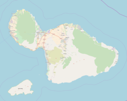
Molokini is a crescent-shaped, partially submerged volcanic crater which forms a small, uninhabited islet located in ʻAlalākeiki Channel between the islands of Maui and Kahoʻolawe, within Maui County in Hawaiʻi. It is the remains of one of the seven Pleistocene epoch volcanoes that formed the prehistoric Maui Nui island, during the Quaternary Period of the Cenozoic Era.
The islet has an area of 23 acres (9.3 ha),[2] a diameter of about 0.4 miles (0.6 km), is 161 feet (50 m) at its highest point,[3] and is located about 2.5 miles (2.2 nmi; 4.0 km) west of Makena State Park and south of Maʻalaea Bay. The islet is a Hawaiʻi State Seabird Sanctuary.
- ^ "Molokini". Geographic Names Information System. United States Geological Survey, United States Department of the Interior.
- ^ "Molokini: Block 9000, Block Group 9, Census Tract 303.02, Maui County, Hawaii". United States Census Bureau. Retrieved July 8, 2011.
- ^ "CRAMP Study Sites: Molokini Island, Island of Maui". Coral Reef Assessment and Monitoring Program. University of Hawaii. Archived from the original on September 24, 2010. Retrieved November 28, 2010.

