| Walthamstow | |
|---|---|
 | |
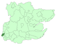
 Walthamstow within Essex in 1961 | |
| Area | |
| • 1911 | 4,343 acres (17.58 km2)[1] |
| • 1931/1961 | 4,342 acres (17.57 km2)[1] |
| Population | |
| • 1911 | 124,580[1] |
| • 1931 | 132,972[1] |
| • 1961 | 108,845[1] |
| Density | |
| • 1911 | 28.7/acre |
| • 1931 | 30.7/acre |
| • 1961 | 25.1/acre |
| History | |
| • Origin | Walthamstow ancient parish (excluding Walthamstow Slip) |
| • Created | 1873 |
| • Abolished | 1965 |
| • Succeeded by | London Borough of Waltham Forest |
| Status | Local board district (1873–1894) Urban district (1894–1929) Municipal borough (1929–1965) |
| Government | Walthamstow Local Board (1873–1894) Walthamstow Urban District Council (1894–1929) Walthamstow Borough Council (1929–1965) |
| • HQ | Town Hall, Orford Road (1876–1941) Town Hall, Forest Road (1941–1965) |
| • Motto | Fellowship is life |
 Coat of arms of the borough council | |
Walthamstow was a local government district in southwest Essex, England from 1873 to 1965, around the town of Walthamstow. It was within the London suburbs, forming part of the London postal district and Metropolitan Police District. Its former area now corresponds to the central part of the London Borough of Waltham Forest in Greater London. Its population and area grew rapidly as London continued to develop its suburbs. [2]
- ^ a b c d e Great Britain Historical GIS / University of Portsmouth, Walthamstow UD/MB population (area and density). Retrieved 2008-02-13.
- ^ Great Britain Historical GIS / University of Portsmouth, Walthamstow UD/MB (historic map). Retrieved 2008-02-13.
