Back مقاطعة نانتو Arabic Nàng-dàu (gâing) CDO Nantou (lalawigan) CEB Okres Nan-tchou Czech Landkreis Nantou German Condado de Nantou Spanish Nantou konderria Basque Nantoun piirikunta Finnish Comté de Nantou French Nantou (Lunkreis) FRR
Nantou County
南投縣 Nan-t'ou | |
|---|---|
 Top:Shuili Water Creek in Shuili Township, 2nd left:Mount Yu, 2nd right:Nantou County Museum of History in Nantou City, 3rd left:View of Sun Moon Lake, from Xuanzang Temple in Yuchi Township, 3rd right:Evergreen Glassland in Renci Township, Bottom left:Tou George Pond in Taiwan Educational University of Nature, Bottom right:Mount Hehuan | |
 | |
 | |
| Coordinates: 23°54′55.28″N 120°41′4.32″E / 23.9153556°N 120.6845333°E | |
| Country | |
| Province | Taiwan (de facto defunct) |
| Seat | Nantou City |
| Largest city | Nantou City |
| Boroughs | 1 city, 12 (4 urban, 8 rural) townships |
| Government | |
| • Body | |
| • County Magistrate | Hsu Shu-hua (KMT) |
| Area | |
• Total | 4,106.436 km2 (1,585.504 sq mi) |
| • Rank | 2 of 22 |
| Population (January 2023) | |
• Total | 479,666 |
| • Rank | 15 of 22 |
| • Density | 120/km2 (300/sq mi) |
| Time zone | UTC+8 (National Standard Time) |
| ISO 3166 code | TW-NAN |
| Website | www.nantou.gov.tw |
| Symbols | |
| Flower | Plum blossom (Prunus mume) |
| Tree | Camphor Laurel (Cinnamomum camphora) |
| Nantou County | |||||||||||||||||||||||||||||
|---|---|---|---|---|---|---|---|---|---|---|---|---|---|---|---|---|---|---|---|---|---|---|---|---|---|---|---|---|---|
| Traditional Chinese | 南投縣 | ||||||||||||||||||||||||||||
| |||||||||||||||||||||||||||||
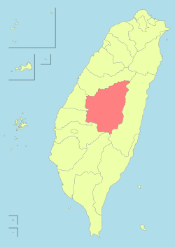
Nantou County (Chinese: 南投縣; pinyin: Nántóu Xiàn; Hokkien POJ: Lâm-tâu-koān; Hakka PFS: Nàm-thèu-yen) is the second largest county of Taiwan by area, located in the central part of the country.[1] It is also the only non-coastal county in Taiwan. Its name derives from the Hoanya Taiwanese aboriginal word Ramtau.[2]
Its mountainous area makes it a tourist destination. The largest natural lake in Taiwan, Sun Moon Lake, is located in this county. Other well-known tourist sites of the county including Aowanda, Formosan Aboriginal Culture Village, Hehuanshan, Paper Dome, Qingjing Farm, Shanlinxi, Shuiyuan Suspension Bridge and Xitou. Notable cities in Nantou are Nantou City and Puli Town. The official butterfly of Nantou County is the broad-tailed swallowtail butterfly (Agehana maraho). Nantou's tung-ting tea is one of the most famous and high-quality oolong teas grown in Taiwan.[3]
- ^ See List of administrative divisions of Taiwan
- ^ 南投的地方起源與變遷 (in Chinese (Taiwan)). Archived from the original on 2012-02-06.
此地原本為平埔族Arikun族南投(Ramtau)社之故址所在,此「南投」之地名即翻譯自平埔族語。
- ^ "Dong Ding Oolong Tea: Product Description" Archived 2016-04-25 at the Wayback Machine. The Brixton Tea Party. 2013. Retrieved April 27, 2013.

