Back राष्ट्रिय राजधानी क्षेत्र (भारत) Bihari জাতীয় রাজধানী অঞ্চল (ভারত) Bengali/Bangla Territori de la Capital Nacional de Delhi Catalan National Capital Region (Indien) German Nacia Ĉefurba Regiono (Barato) Esperanto Delhi liiduterritoorium Estonian राष्ट्रीय राजधानी क्षेत्र Hindi デリー首都圏 Japanese დელი (მოკავშირე ტერიტორია) Georgian Nationalis Capitis Regio (India) Latin
National Capital Region
Rāṣṭrīya Rājadhānī Kṣētra NCR | |
|---|---|
 Location of the NCR in India | |
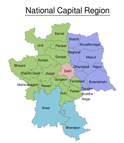
 Map of the National Capital Region, showing the union territory of Delhi (red) and states and the boundaries of their districts. The states shown are: Haryana (green), Rajasthan (blue), and Uttar Pradesh (purple). | |
| Coordinates: 28°39′38″N 77°06′32″E / 28.66056°N 77.10889°E | |
| Country | |
| States | |
| Union territory | |
| Created | 1985[1] |
| Major cities | Delhi, Faridabad, Ghaziabad, Gurugram, Noida |
| Government | |
| • Regional authority | National Capital Region Planning Board |
| Area | |
• Total | 55,083 km2 (21,268 sq mi) |
| Population | |
• Total | 46,069,000 |
| • Density | 840/km2 (2,200/sq mi) |
| GDP | |
| • Total | US$272.603 billion |
| Time zone | UTC+05:30 (IST) |
| Website | ncrpb |
The National Capital Region (NCR; Hindi: राष्ट्रीय राजधानी क्षेत्र, Rāṣṭrīya Rājadhānī Kṣētra) is a planning region centred upon the National Capital Territory (NCT) of Delhi in India. It encompasses Delhi and several districts surrounding it from the states of Haryana, Uttar Pradesh, and Rajasthan.[2] The NCR and the associated National Capital Region Planning Board (NCRPB) were created in 1985 to plan the development of the region and to evolve harmonized policies for the control of land-uses and development of infrastructure in the region.[5] Prominent cities of NCR include Delhi, Faridabad, Ghaziabad, Gurgaon and Noida.
The NCR is a rural-urban region, with a population of over 46,069,000 and an urbanisation level of 62.6%.[3] As well as the cities and towns, the NCR contains ecologically sensitive areas like the Aravalli ridge, forests, wildlife and bird sanctuaries.[6] The Delhi Extended Urban Agglomeration, a part of the NCR, had an estimated GDP of $370 billion (measured in terms of GDP PPP) in 2015–16.[7]
Despite being a part of the NCR, the Government of India's think tank, NITI Aayog, listed the Nuh district of Haryana as the most underdeveloped compared to all of India's 739 districts.[8]
- ^ Cite error: The named reference
NCRPBA85was invoked but never defined (see the help page). - ^ a b "NCR Constituent Areas". National Capital Region Planning Board. Archived from the original on 3 April 2023.
- ^ a b "Census 2011" (PDF). National Capital Region Planning Board. National Informatics Centre. p. 3. Archived from the original (PDF) on 6 April 2016. Retrieved 26 March 2016.
- ^ "Global Wealth GDP Nominal Distribution: Who Are The Leaders Of The Global Economy? - Full Size". www.visualcapitalist.com. Retrieved 27 March 2022.
- ^ Cite error: The named reference
1985actwas invoked but never defined (see the help page). - ^ "NCR expands, planning lags". The Indian Express. 18 January 2014. Archived from the original on 20 March 2017. Retrieved 19 March 2017.
- ^ "With GDP of $370 billion, Delhi-NCR muscles out Mumbai as economic capital of India". The Financial Express. 29 November 2016. Archived from the original on 10 July 2017. Retrieved 14 July 2017.
- ^ "Nuh at bottom of Niti Aayog's 101 most backward districts". The Hindu. 1 April 2018. ISSN 0971-751X. Retrieved 22 August 2023.


