Back كاسكيد الشمالية Arabic كاسكيد الشماليه ARZ Severní Kaskády Czech Nördliche Kaskadenkette German Cascadas del Norte Spanish کسکیدز شمالی Persian North Cascades French North Cascades Italian North Cascades SIMPLE
| North Cascades | |
|---|---|
| Canadian Cascades | |
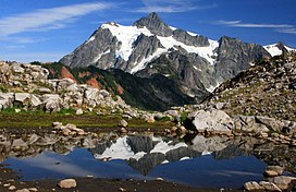
 Mount Shuksan, one of the most picturesque peaks of the North Cascades | |
| Highest point | |
| Peak | Mount Baker |
| Elevation | 3,286 m (10,781 ft) |
| Dimensions | |
| Length | 434.5 km (270.0 mi) North-South |
| Width | 241 km (150 mi) East-West |
| Geography | |
| Countries | |
| Province/State | |
| Parent range | Cascade Range |
| Borders on | Lillooet Ranges, Skagit Range |
The North Cascades are a section of the Cascade Range of western North America. They span the border between the Canadian province of British Columbia and the U.S. state of Washington and are officially named in the U.S. and Canada[1] as the Cascade Mountains.[2] The portion in Canada is known to Americans as the Canadian Cascades, a designation that also includes the mountains above the east bank of the Fraser Canyon as far north as the town of Lytton, at the confluence of the Thompson and Fraser Rivers.
They are predominantly non-volcanic, but include the stratovolcanoes Mount Baker, Glacier Peak and Coquihalla Mountain, which are part of the Cascade Volcanic Arc.
- ^ Government of Canada, Natural Resources Canada. "Place names - Search Results". rncan.gc.ca. Retrieved April 11, 2018.
- ^ "Cascade Mountains". BC Geographical Names.
