| Northwest Branch Anacostia River | |
|---|---|
 | |
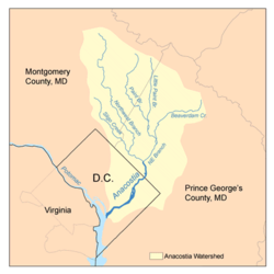
 Map of the Anacostia River watershed showing the Northwest Branch | |
| Location | |
| Country | United States |
| State | Maryland |
| Cities | Wheaton, Silver Spring, Hyattsville |
| Physical characteristics | |
| Source | |
| • location | Sandy Spring, Maryland |
| Mouth | Anacostia River |
• location | Bladensburg, MD |
• coordinates | 38°56′34″N 76°56′39″W / 38.942832°N 76.944036°W |
| Length | 21.5 mi (34.6 km) |
| Basin size | 53.5 sq mi (139 km2) |
| Basin features | |
| Tributaries | |
| • left | Old Orchard, Bryants Nursery, Norwood, Rolling Stone |
| • right | Bachelors Forest, Longmeade, Bel Pre Creek, Wheaton Park, Lamberton Dr, Sligo Creek |
Northwest Branch Anacostia River is a 21.5-mile-long (34.6 km)[1] free-flowing stream in Montgomery County and Prince George's County, Maryland. It is a tributary of the Anacostia River, which flows to the Potomac River and the Chesapeake Bay.
- ^ "The National Map". National Hydrography Dataset high-resolution flowline data. U.S. Geological Survey. Retrieved August 15, 2011.
