Back أوداناك (كيبك) Arabic Odanak ATJ Odanak CEB Odanak German Odanak (réserve indienne) French Оданак Russian Odanak Swedish
Odanak | |
|---|---|
 Saint-François-de-Sales church | |
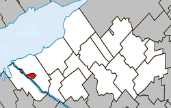
 Location within Nicolet-Yamaska RCM | |
| Coordinates: 46°04′N 72°50′W / 46.067°N 72.833°W[1] | |
| Country | |
| Province | |
| Region | Centre-du-Québec |
| RCM | None |
| Constituted | unspecified |
| Government | |
| • Type | Band council |
| • Federal riding | Bas-Richelieu—Nicolet—Bécancour |
| • Prov. riding | Nicolet-Bécancour |
| Area | |
• Total | 5.70 km2 (2.20 sq mi) |
| • Land | 5.61 km2 (2.17 sq mi) |
| Population | |
• Total | 481 |
| • Density | 85.8/km2 (222/sq mi) |
| • Dwellings | 243 |
| Time zone | UTC−5 (EST) |
| • Summer (DST) | UTC−4 (EDT) |
| Area code | 450 |
| Access Routes[5] | |
Odanak is an Abenaki First Nations reserve in the Central Quebec region, Quebec, Canada. The mostly First Nations population as of the 2021 Canadian census was 481. The territory is located near the mouth of the Saint-François River at its confluence with the St. Lawrence River. It is partly within the limits of Pierreville and across the river from Saint-François-du-Lac. Odanak is an Abenaki word meaning "in the village".
- ^ Cite error: The named reference
toponymiewas invoked but never defined (see the help page). - ^ a b Ministère des Affaires municipales, des Régions et de l'Occupation du territoire: Odanak
- ^ "Parliament of Canada Federal Riding History: BAS-RICHELIEU--NICOLET--BÉCANCOUR (Quebec)". Archived from the original on 2009-06-09. Retrieved 2009-06-21.
- ^ a b 2021 Statistics Canada Census Profile: Odanak
- ^ Official Transport Quebec Road Map

