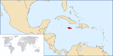

The following outline is provided as an overview of and topical guide to Jamaica:
Jamaica – sovereign island nation located on the Island of Jamaica of the Greater Antilles archipelago in the Caribbean Sea.[1] It is 234 kilometres (145 mi) long and 80 kilometres (50 mi) at its widest. It lies about 145 kilometres (90 mi) south of Cuba and 190 kilometres (120 mi) west of the Hispaniola. Its indigenous Arawakan-speaking Taíno inhabitants named the island Xaymaca, meaning the "Land of Wood and Water", or the "Land of Springs".[2] Formerly a Spanish possession known as Santiago, it later became the British West Indies Crown colony of Jamaica. It is the third most populous anglophone country in the Americas, after the United States and Canada.
- ^ "Jamaica". The World Factbook. United States Central Intelligence Agency. July 6, 2009. Retrieved July 23, 2009.
- ^ The United Confederation of Taíno People. "Taíno Dictionary" (in Spanish). Archived from the original on 2007-10-16. Retrieved 2007-10-18.


