Back Paramaribô ACE Paramaribo Afrikaans ፓራማሪቦ Amharic Paramaribo AN باراماريبو Arabic پاراماريبو ARY باراماريبو ARZ Paramaribu AST Paramaribo AVK Paramaribo Aymara
Paramaribo | |
|---|---|
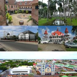
 Clockwise from left: Fort Zeelandia, Garden of Palms, Arya Diwaker, Saint Peter and Paul Cathedral and its surroundings, and Mosque Keizerstraat adjacent to the Neveh Shalom Synagogue | |
| Nickname(s): | |
Location in Suriname and South America | |
| Coordinates: 5°51′8″N 55°12′14″W / 5.85222°N 55.20389°W | |
| Country | Suriname |
| District | Paramaribo District |
| Founded | 1613 |
| Area | |
• Total | 182 km2 (70 sq mi) |
| Elevation | 3 m (10 ft) |
| Population (2012 census)[1] | |
• Total | 240,924 |
| • Density | 1,300/km2 (3,400/sq mi) |
| Time zone | UTC-03:00 (Suriname Time) |
| • Summer (DST) | (not observed) |
Paramaribo (UK: /ˌpærəˈmærɪboʊ/ PARR-ə-MARR-ib-oh, US: /ˌpɑːrəˈmɑːrɪboʊ/ PAR-ə-MAR-ib-oh, Dutch: [ˌpaːraːˈmaːriboː] ⓘ) is the capital and largest city of Suriname, located on the banks of the Suriname River in the Paramaribo District. Paramaribo has a population of roughly 241,000 people (2012 census), almost half of Suriname's population.[1] The historic inner city of Paramaribo has been a UNESCO World Heritage Site since 2002.[2]
- ^ a b Cite error: The named reference
censuswas invoked but never defined (see the help page). - ^ "Historic Inner City Paramaribo". Unesco.org. Retrieved 29 May 2020.

