Back পাতিয়ালা ও পূর্ব পাঞ্জাব রাজ্য ইউনিয়ন Bengali/Bangla Patiala and East Punjab States Union German Unión de Estados de Patiala y de Punyab Oriental Spanish اتحادیه ایالات پتیاله و پنجاب شرقی Persian Union des États de Patiala et du Pendjab oriental French पटियाला एवं पूर्वी पंजाब राज्य संघ Hindi पतियाळा आणि पूर्व पंजाब राज्य संघ Marathi ਪਟਿਆਲਾ ਅਤੇ ਪੂਰਬੀ ਪੰਜਾਬ ਸਟੇਟਸ ਯੂਨੀਅਨ Punjabi Патиала и союз государств восточного Пенджаба Russian Patiala and East Punjab States Union SIMPLE
| Patiala and East Punjab States Union | |||||||||||||||
|---|---|---|---|---|---|---|---|---|---|---|---|---|---|---|---|
| State of India | |||||||||||||||
| 1948–1956 | |||||||||||||||
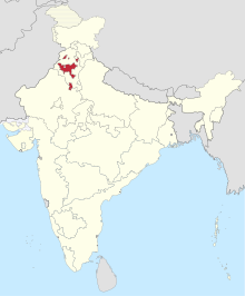
 1951 map of India. The Patiala and East Punjab States Union is shown forming enclaves in East Punjab. | |||||||||||||||
| Capital | Patiala | ||||||||||||||
| Area | |||||||||||||||
• 1951 | 26,208 km2 (10,119 sq mi) | ||||||||||||||
| Population | |||||||||||||||
• 1951 | 3,493,685 | ||||||||||||||
| • Type | Democracy | ||||||||||||||
| Legislature | Patiala and East Punjab States Union Legislative Assembly | ||||||||||||||
| History | |||||||||||||||
• State Established | 15 July 1948 | ||||||||||||||
• State Disestablished | 1 November 1956 | ||||||||||||||
| |||||||||||||||
| Today part of | India | ||||||||||||||
The Patiala and East Punjab States Union (PEPSU) was a state of India, uniting eight princely states between 1948 and 1956. The capital and principal city was Patiala. The state covered an area of 26,208 km2. Shimla, Kasauli, Kandaghat and Chail also became part of PEPSU.

