| Pic River | |
|---|---|
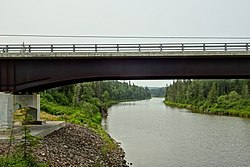
 Bridge of Highway 17 over the Pic River | |
| Location | |
| Country | Canada |
| Province | Ontario |
| Region | Northwestern Ontario |
| District | Thunder Bay |
| Physical characteristics | |
| Source | McKay Lake |
| • coordinates | 49°37′42″N 86°17′00″W / 49.62833°N 86.28333°W |
| • elevation | 321 m (1,053 ft) |
| Mouth | Lake Superior |
• coordinates | 48°36′01″N 86°18′09″W / 48.60028°N 86.30250°W |
• elevation | 180 m (590 ft) |
| Length | 150 km (93 mi) |
| Basin features | |
| Tributaries | |
| • left | Black River, White Otter River |
| • right | Kagiano River |
The Pic River is a river in the east part of Thunder Bay District in northwestern Ontario, Canada. It flows from McKay Lake southeast of the community of Longlac and empties into Lake Superior southeast of the town of Marathon.

