Back بيملكو Arabic Pimliko Azerbaijani پیملیکو AZB Pimlico Welsh Pimlico (London) German Pimlico Spanish پیملیکو Persian Pimlico French Pimlico Irish פימליקו HE
| Pimlico | |
|---|---|
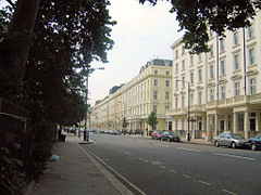
 Belgrave Road from St George's Square | |
 Map of Pimlico | |
Location within Greater London | |
| OS grid reference | TQ295785 |
| London borough | |
| Ceremonial county | Greater London |
| Region | |
| Country | England |
| Sovereign state | United Kingdom |
| Post town | LONDON |
| Postcode district | SW1V |
| Dialling code | 020 |
| Police | Metropolitan |
| Fire | London |
| Ambulance | London |
| UK Parliament | |
| London Assembly | |
Pimlico (/ˈpɪmlɪkoʊ/) is an area of Central London in the City of Westminster, built as a southern extension to neighbouring Belgravia.[1] It is known for its garden squares and distinctive Regency architecture. Pimlico is demarcated to the north by Victoria Station, by the River Thames to the south, Vauxhall Bridge Road to the east and the former Grosvenor Canal to the west. At its heart is a grid of residential streets laid down by the planner Thomas Cubitt, beginning in 1825 and now protected as the Pimlico Conservation Area. The most prestigious are those on garden squares, with buildings decreasing in grandeur away from St George's Square, Warwick Square, Eccleston Square and the main thoroughfares of Belgrave Road and St. George's Drive.
Additions have included the pre–World War II Dolphin Square and the Churchill Gardens and Lillington and Longmoore Gardens estates, now conservation areas in their own right. The area has over 350 Grade II listed buildings and several Grade II* listed churches. At the western edge of Pimlico, on the borders of Chelsea, Pimlico Road has in recent years seen a loss of traditional local retail, replaced by upscale interiors and design stores.
- ^ "London's Places" (PDF). London Plan. Greater London Authority. 2011. p. 46. Archived (PDF) from the original on 6 September 2015. Retrieved 27 May 2014.
