Back بوابة:بوليفيا Arabic Portal:Bolivien German Portal:Bolivia Spanish Portail:Bolivie French Portale:Bolivia Italian Портал:Боливија Macedonian Portal:Bolivia Malay Portal:Bolívia Portuguese Punku p'anqa: Buliwya Quechua Портал:Боливия Russian
| Portal | WikiProject | Peer Review | Assessment | Task Force |
IntroductionWelcome to the Bolivia portal
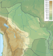
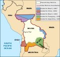
  Bolivia, officially the Plurinational State of Bolivia, is a landlocked country located in central South America. The country features diverse geography, including vast Amazonian plains, tropical lowlands, mountains, the Gran Chaco Province, warm valleys, high-altitude Andean plateaus, and snow-capped peaks, encompassing a wide range of climates and biomes across its regions and cities. It includes part of the Pantanal, the largest tropical wetland in the world, along its eastern border. It is bordered by Brazil to the north and east, Paraguay to the southeast, Argentina to the south, Chile to the southwest, and Peru to the west. The seat of government is La Paz, which contains the executive, legislative, and electoral branches of government, while the constitutional capital is Sucre, the seat of the judiciary. The largest city and principal industrial center is Santa Cruz de la Sierra, located on the Llanos Orientales (eastern tropical lowlands), a mostly flat region in the east of the country with a diverse non-Andean culture. The sovereign state of Bolivia is a constitutionally unitary state divided into nine departments. Its geography varies as the elevation fluctuates, from the western snow-capped peaks of the Andes to the eastern lowlands, situated within the Amazon basin. One-third of the country is within the Andean mountain range. With an area of 1,098,581 km2 (424,164 sq mi), Bolivia is the fifth-largest country in South America after Brazil, Argentina, Peru and Colombia, and, alongside Paraguay, is one of two landlocked countries in the Americas. It is the largest landlocked country in the Southern Hemisphere. The country's population, estimated at 12 million, is multiethnic, including Amerindians, Mestizos, and the descendants of Europeans and Africans. Spanish is the official and predominant language, although 36 indigenous languages also have official status, of which the most commonly spoken are Guaraní, Aymara, and Quechua. 20th century Bolivia experienced a succession of military and civilian governments until Hugo Banzer led a US-backed coup d'état in 1971, replacing the socialist government of Juan José Torres with a military dictatorship. Banzer's regime cracked down on left-wing and socialist opposition parties, and other perceived forms of dissent, resulting in the torturing and murders of countless Bolivian citizens. Banzer was ousted in 1978 and, twenty years later, returned as the democratically elected President of Bolivia (1997–2001). Under the 2006–2019 presidency of Evo Morales, the country saw significant economic growth and political stability but was also accused of democratic backsliding, and was described as a competitive authoritarian regime. Freedom House classifies Bolivia as a partly-free democracy as of 2023, with a 66/100 score. (Full article...) Selected article -Salar de Uyuni (or "Salar de Tunupa") is the world's largest salt flat, or playa, at 10,582 square kilometres (4,086 sq mi) in area. It is in the Daniel Campos Province in Potosí in southwest Bolivia, near the crest of the Andes at an elevation of 3,656 m (11,995 ft) above sea level. The Salar was formed as a result of transformations between several prehistoric lakes that existed around forty thousand years ago but had all evaporated over time. It is now covered by a few meters of salt crust, which has an extraordinary flatness with the average elevation variations within one meter over the entire area of the Salar. The crust serves as a source of salt and covers a pool of brine, which is exceptionally rich in lithium. The large area, clear skies, and exceptional flatness of the surface make the Salar ideal for calibrating the altimeters of Earth observation satellites. Following rain, a thin layer of dead calm water transforms the flat into the world's largest mirror, 129 km (80 miles) across. (Full article...) Did you know (auto-generated)
Selected pictureTopicsLargest populated areas
Related portals
WikiProjectsAssociated WikimediaDiscover Wikipedia using portals New ArticlesThis list was generated from these rules. Questions and feedback are always welcome! The search is being run daily with the most recent ~14 days of results. Note: Some articles may not be relevant to this project.
Rules | Match log | Results page (for watching) | Last updated: 2025-01-11 19:46 (UTC) Note: The list display can now be customized by each user. See List display personalization for details.
| |||||||||||||||||||||||||||||||||||||||||||||||||||||||||||||||||||||||||||||||||||||||||||||||||||||||||||||||||||||||||||||||||||||||||||||||||||||


