| Ward of Portsoken | |
|---|---|
 | |
Location within Greater London | |
| Population | 985 (2011 Census. Ward)[2] |
| Ceremonial county | Greater London |
| Region | |
| Country | England |
| Sovereign state | United Kingdom |
| Post town | LONDON |
| Postcode district | E1 |
| Postcode district | EC3 |
| Dialling code | 020 |
| Police | Metropolitan |
| Fire | London |
| Ambulance | London |
| UK Parliament | |
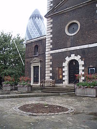
Portsoken, traditionally referred to with the definite article as the Portsoken,[3] is one of the City of London, England's 25 ancient wards, which are still used for local elections. Historically an extra-mural ward, lying east of the former London Wall, the area is sometimes considered to be part of the East End of London.[4]
The ward is about 5 hectares in area, and is mainly oriented north-south, with the central part informally known as Aldgate while to its north as Bishopsgate.
- ^ If you look carefully you can see the Portsoken Bulletin, detailing the ward officers.
- ^ "City of London Ward population 2011". Neighbourhood Statistics. Office for National Statistics. Retrieved 16 October 2016.
- ^ for instance, passim throughout "London 800-1216", by Brooke and Keir
- ^ Guide to tours of the Jewish East End published by LBTH, 2003, https://www.towerhamlets.gov.uk/Documents/Leisure-and-culture/Tourism/Visitor-information/Jewish-East-End-walk-leaflet.pdf

