Back مقاطعة بويبلو (كولورادو) Arabic Pueblo County, Colorado BAR Пуэбла (акруга) Byelorussian Пуебло (окръг) Bulgarian পুয়েবলো কাউন্টি, কলোরাডো BPY Pueblo Gông (Colorado) CDO Пуэбло (гуо, Колорадо) CE Pueblo County CEB Pueblo County Czech Pueblo County, Colorado Welsh
Pueblo County | |
|---|---|
 The Pueblo County Courthouse with brass dome in Pueblo | |
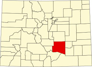
 Location within the U.S. state of Colorado | |
 Colorado's location within the U.S. | |
| Coordinates: 38°09′N 104°31′W / 38.15°N 104.51°W | |
| Country | |
| State | |
| Founded | November 1, 1861 |
| Named for | City of Pueblo |
| Seat | Pueblo |
| Largest city | Pueblo |
| Area | |
• Total | 2,398 sq mi (6,210 km2) |
| • Land | 2,386 sq mi (6,180 km2) |
| • Water | 12 sq mi (30 km2) 0.5% |
| Population (2020) | |
• Total | 168,162 |
• Estimate (2023)[1] | 169,422 |
| • Density | 71/sq mi (27/km2) |
| Time zone | UTC−7 (Mountain) |
| • Summer (DST) | UTC−6 (MDT) |
| Congressional district | 3rd |
| Website | county |
Pueblo County (/ˈpwɛbloʊ/ or /ˈpjɛbloʊ/) is a county located in the U.S. state of Colorado. As of the 2020 census, the population was 168,162.[2] The county seat is Pueblo.[3] The county was named for the historic city of Pueblo which took its name from the Spanish language word meaning "town" or "village". Pueblo County comprises the Pueblo, CO Metropolitan Statistical Area.[4][5]
- ^ "Annual Estimates of the Resident Population for Counties: April 1, 2020 to July 1, 2023". United States Census Bureau. Retrieved March 24, 2024.
- ^ "State & County QuickFacts". United States Census Bureau. Retrieved September 5, 2021.
- ^ "Find a County". National Association of Counties. Retrieved June 7, 2011.
- ^ "OMB Bulletin No. 10-02: Update of Statistical Area Definitions and Guidance on Their Uses" (PDF). Office of Management and Budget. December 1, 2009. Archived (PDF) from the original on January 21, 2017. Retrieved April 19, 2012 – via National Archives.
- ^ See the Colorado census statistical areas.
