Back رابول Arabic رابول ARZ Рабаул Byelorussian Рабаул Bulgarian Rabaul Breton Rabaul Catalan Rabaul (lungsod) CEB Rabaul Czech Rabaul Danish Rabaul German
Rabaul | |
|---|---|
 Rabaul from the Vulcanology Observatory, with the old town to the left and the new town to the right | |
| Coordinates: 4°12′S 152°11′E / 4.200°S 152.183°E | |
| Country | Papua New Guinea |
| Province | East New Britain |
| LLG | Rabaul Urban LLG |
| Established | 1878[1] |
| Population | |
• Total | 3,885 17,044 (1,990) |
| Languages | |
| • Main languages | Tok Pisin, Kuanua, English |
| • Traditional language | Kuanua |
| Time zone | UTC+10 (AEST) |
| Postcode | 611 |
| Climate | Af |
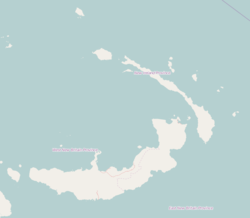
Rabaul (/rɑːˈbaʊl/) is a township in the East New Britain province of Papua New Guinea, on the island of New Britain. It lies about 600 kilometres to the east of the island of New Guinea. Rabaul was the provincial capital and most important settlement in the province until it was destroyed in 1994 by falling ash from a volcanic eruption in its harbor. During the eruption, ash was sent thousands of metres into the air, and the subsequent rain of ash caused 80% of the buildings in Rabaul to collapse. After the eruption the capital was moved to Kokopo, about 20 kilometres (12 mi) away. Rabaul is continually threatened by volcanic activity, because it is on the edge of the Rabaul caldera, a flooded caldera of a large pyroclastic shield volcano.
Rabaul was planned and built around the harbour area known as Simpsonhafen (Simpson Harbour) during the German New Guinea administration, which controlled the region from 1884 and formally through 1919. Rabaul was selected as the capital of the German New Guinea administration in 1905, and the administrative offices were transferred there in 1910.[2] Rabaul was captured by the British Empire during the early days of World War I.[3] It became the capital of the Australian-mandated Territory of New Guinea until 1937, when it was first destroyed by a volcano.[4] During World War II, it was captured by Japan in 1942 and became its main base of military and naval activity in the South Pacific. Settlements and military installations around the edge of the caldera are often collectively called Rabaul, although the old town of Rabaul was reduced to practical insignificance by the volcanic eruption in 1937.
As a tourist destination, Rabaul is popular for its volcanoes, scuba diving and for snorkelling sites, spectacular harbour and other scenery, World War II history, flora and fauna, and the cultural life of the Tolai people. Before the 1994 eruption, Rabaul was a popular commercial and recreational boating destination; fewer private small craft visit now, but 10 to 12 cruise ships visit Rabaul each year, including the Queen Elizabeth, carrying up to 2,000 passengers. Tourism is a major industry in Rabaul and East New Britain generally.
- ^ History of Rabaul, retrieved 2009-11-05
- ^ Thomas, Gordon (15 February 1946). "The Story of Rabaul – Thirty-five Years a South Seas Storm Centre (1)". XVI(7) Pacific Islands Monthly. Retrieved 29 September 2021.
- ^ Thomas, Gordon (15 March 1946). "The Story of Rabaul – Thirty-five Years a South Seas Storm Centre (2)". XVI(8) Pacific Islands Monthly. Retrieved 29 September 2021.
- ^ Thomas, Gordon (16 April 1946). "The Story of Rabaul – Thirty-five Years a South Seas Storm Centre (3)". XVI(9) Pacific Islands Monthly. Retrieved 29 September 2021.
