Back কর্তব্য পথ Bengali/Bangla Rádžpath Czech Rajpath Spanish Rajpath French ראג'פאט HE राजपथ Hindi राजपथ MAI രാജ്പഥ് Malayalam Rajpath NB Rajpath Portuguese
This article needs additional citations for verification. (February 2023) |
| Kartavya Path | |
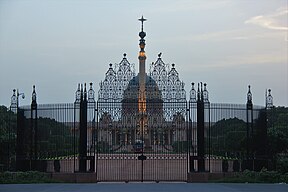
From top: India Gate on the eastern end of Rajpath ; Rashtrapati Bhavan on the western end of Rajpath | |
 Rajpath, located in New Delhi, India | |
| Former name(s) | Kingsway |
|---|---|
| Location | New Delhi, India |
| Nearest metro station | Central Secretariat metro station |
| Coordinates | 28°36′48″N 77°13′06″E / 28.613388°N 77.218397°E |
| Construction | |
| Inauguration | 1911 |
| Other | |
| Designer | Sir Edwin Lutyens |
| Status | Heritage status |
Rajpath, officially named Kartavya Path[1] (transl. Path of Duty[2]), and formerly known as Kingsway, is a ceremonial boulevard in New Delhi, India, that runs from Rashtrapati Bhavan on Raisina Hill through Vijay Chowk and India Gate, National War Memorial to National Stadium, Delhi. The avenue is lined on both sides by huge lawns, canals and rows of trees. Considered to be one of the most important roads in India, it is where the annual Republic Day parade takes place on 26 January. Janpath (meaning "People's Way") crosses the road. Rajpath runs in east-west direction. Roads from Connaught Place, the financial centre of Delhi, run into Rajpath from north. It was made during the Construction of New Delhi.
After climbing Raisina Hill, Rajpath is flanked by the North and South Blocks of the Secretariat Building. Finally it ends at the gates of Rashtrapati Bhavan. At Vijay Chowk it crosses Sansad Marg, and the Parliament House of India can be seen to the right when coming from the India Gate.
It is also used for the funeral processions of key political leaders of India.
- ^ "NDMC passes resolution to rename Rajpath to Kartavya Path". The Hindu. 7 September 2022. ISSN 0971-751X. Retrieved 8 September 2022.
- ^ "Rajpath to make way for Kartavya Path: How India is stepping away from its colonial past". Firstpost. 6 September 2022. Retrieved 27 December 2023.

