| Richardson Grove State Park | |
|---|---|
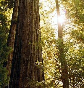
 Redwoods tower over the Eel River on either bank. | |
| Location | Humboldt County, California, United States |
| Nearest city | Rio Del |
| Coordinates | 40°01′N 123°48′W / 40.017°N 123.800°W |
| Area | 2,000 acres (8.1 km2) |
| Established | 1922 |
| Governing body | California Department of Parks and Recreation |
Richardson Grove State Park is located at the southernmost border of Humboldt County, 75 miles (121 km) south of Eureka, California, United States, and 200 miles (320 km) north of San Francisco. The year-round park, which has approximately 2,000 acres (8.1 km2), straddles US 101, causing the narrowest point of its entire distance. Said to have the 9th largest tree of all remaining Coast Redwoods, it is known for swimming on the South Fork of the Eel River[1] and day use in addition to 159 campsites.[2]
The park is named after Friend Richardson, the 25th Governor of California between 1923 and 1927.[3]
- ^ "Richardson Grove State Park". California State Parks. 2009. Retrieved July 8, 2009.
- ^ "Richardson Grove State Park" (PDF). Humboldt Redwoods Interpretive Association. 2002. Archived from the original (PDF) on October 25, 2007. Retrieved September 24, 2007.
- ^ "Richardson Grove State Park". California State Parks. 2007. Retrieved September 24, 2007.


