Back Rif (Atlasgebergte) Afrikaans الريف (المغرب) Arabic Rif AST Эр-Рыф Byelorussian Эр-Рыф BE-X-OLD Риф (планина) Bulgarian রিফ পর্বতমালা Bengali/Bangla Rif (Maroko) Breton Rif Catalan Er Rif CEB
| Rif | |
|---|---|
 A view of the Rif mountains around Chefchaouen | |
| Highest point | |
| Peak | Jbel Tidirhine |
| Elevation | 2,455 m (8,054 ft) |
| Naming | |
| Native name | |
| Geography | |
| Country | Morocco |
| Range coordinates | 35°N 4°W / 35°N 4°W |
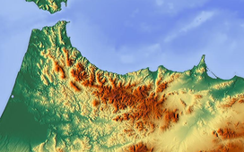
The Rif (Tarifit: ⴰⵔⵔⵉⴼ, ⴰⵔⵉⴼ, romanized: Arrif, Arif, Arabic: الريف), also called Rif Mountains, is a geographic region in northern Morocco. It is bordered on the north by the Mediterranean Sea and Spain and on the west by the Atlantic Ocean, and is the homeland of the Rifians and the Jebala people. This mountainous and fertile area is bordered by Cape Spartel and Tangier to the west, by Berkane and the Moulouya River to the east, by the Mediterranean to the north, and by the Ouergha River to the south. The Rif mountains are separated into the eastern Rif mountains (Nador, Driouch, Al Hoceima) and western Rif mountains (Tangier, Tetouan, Chefchaouen, Taounate).[1]
- ^ "Rif | mountains, Morocco | Britannica". www.britannica.com. Retrieved 2022-05-31.
