Back رويببورن Arabic رويببورن ARZ Roebourne (lungsod) CEB Roebourne German Roebourne Spanish رویبورن، استرالیای غربی Persian Roebourne Malagasy Roebourne Dutch Roebourne Polish Roebourne Portuguese
| Roebourne Yirramagardu (Ngarluma) Western Australia | |||||||||
|---|---|---|---|---|---|---|---|---|---|
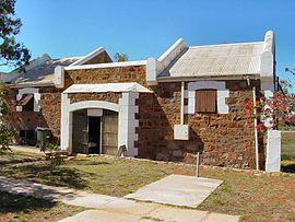
 Roebourne Tourist Centre (formerly the entrance to Roebourne Gaol) | |||||||||
 | |||||||||
| Coordinates | 20°46′00″S 117°09′00″E / 20.76667°S 117.15000°E | ||||||||
| Population | 700 (UCL 2021)[1] | ||||||||
| Established | Proclaimed a township on 17 August 1866 | ||||||||
| Postcode(s) | 6718 | ||||||||
| Elevation | 12 m (39 ft) | ||||||||
| Area | 175.8 km2 (67.9 sq mi) | ||||||||
| Location |
| ||||||||
| LGA(s) | City of Karratha | ||||||||
| State electorate(s) | North West | ||||||||
| Federal division(s) | Durack | ||||||||
| |||||||||
Roebourne /ˈroʊbərn/, also known by its Ngarluma name Ieramugadu (also spelt Yirramagardu), is a town in Western Australia's Pilbara region. It is 35 km from Karratha, 202 km from Port Hedland and 1,563 km from Perth, the state's capital. It is the only town on the North West Coastal Highway between Binnu and Fitzroy Crossing; over 2,000km. It is located within the City of Karratha. It prospered during its gold boom of the late 19th century and was once the largest settlement between Darwin and Perth. At the 2016 census, Roebourne and the surrounding area had a population of 981.[2]
- ^ Australian Bureau of Statistics (28 June 2022). "Roebourne (urban centre and locality)". Australian Census 2021.
- ^ Australian Bureau of Statistics (27 June 2017). "Roebourne (state suburb)". 2016 Census QuickStats. Retrieved 22 January 2018.
