Back مقاطعة روزفلت (مونتانا) Arabic Roosevelt County, Montana BAR Рузвелт (окръг, Монтана) Bulgarian রোজবেল্ট কাউন্টি, মন্টানা BPY Roosevelt Gông (Montana) CDO Roosevelt County (kondado sa Tinipong Bansa, Montana) CEB Roosevelt County, Montana Welsh Roosevelt County (Montana) German Κομητεία Ρούζβελτ (Μοντάνα) Greek Kantono Roosevelt (Montano) Esperanto
Roosevelt County | |
|---|---|
 Roosevelt County Courthouse in Wolf Point | |
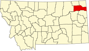
 Location within the U.S. state of Montana | |
 Montana's location within the U.S. | |
| Coordinates: 48°18′N 105°02′W / 48.3°N 105.03°W | |
| Country | |
| State | |
| Founded | 1919 |
| Named for | Theodore Roosevelt |
| Seat | Wolf Point |
| Largest city | Wolf Point |
| Area | |
• Total | 2,369 sq mi (6,140 km2) |
| • Land | 2,355 sq mi (6,100 km2) |
| • Water | 15 sq mi (40 km2) 0.6% |
| Population (2020) | |
• Total | 10,794 |
• Estimate (2022) | 10,572 |
| • Density | 4.6/sq mi (1.8/km2) |
| Time zone | UTC−7 (Mountain) |
| • Summer (DST) | UTC−6 (MDT) |
| Congressional district | 2nd |
| Website | www |
| |
Roosevelt County is a county in the U.S. state of Montana. As of the 2020 census, the population was 10,794.[1] Its county seat is Wolf Point.[2] Roosevelt County was created by the Montana Legislature in 1919 from a portion of Sheridan County. The name honors former president Theodore Roosevelt, who had died earlier that year.[3]
- ^ "State & County QuickFacts". United States Census Bureau. Retrieved May 7, 2023.
- ^ "Find a County". National Association of Counties. Retrieved June 7, 2011.
- ^ "Montana Place Names Companion". Montana Place Names From Alzada to Zortman. Montana Historical Society Research Center. Retrieved May 9, 2011.