Back San Bernardino National Forest CEB San Bernardino National Forest German جنگل ملی سن برناردینو Persian Forêt nationale de San Bernardino French സാൻ ബർണാർഡിനൊ ദേശീയ വനം Malayalam 圣贝纳迪诺国家森林 Chinese
This article needs additional citations for verification. (March 2012) |
| San Bernardino National Forest | |
|---|---|
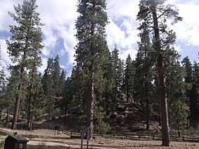
 Forest near Fawnskin | |
| Location | San Bernardino / Riverside counties, California, United States |
| Nearest city | San Bernardino |
| Coordinates | 34°08′00″N 117°00′36″W / 34.13333°N 117.01000°W |
| Area | 823,816 acres (3,333.87 km2)[1] |
| Established | 1907 |
| Governing body | U.S. Forest Service |
| Website | San Bernardino National Forest |
The San Bernardino National Forest is a United States national forest in Southern California encompassing 823,816 acres (3,333.87 km2) of which 677,982 acres (2,743.70 km2) are federal.[1] The forest is made up of two main divisions, the eastern portion of the San Gabriel Mountains and the San Bernardino Mountains on the easternmost of the Transverse Ranges, and the San Jacinto and Santa Rosa Mountains on the northernmost of the Peninsular Ranges. Elevations range from 2,000 to 11,499 feet (600 to 3505 m). The forest includes seven wilderness areas:[2] San Gorgonio, Cucamonga, San Jacinto, South Fork, Santa Rosa, Cahuilla Mountain and Bighorn Mountain. Forest headquarters are located in the city of San Bernardino. There are district offices in Lytle Creek, Idyllwild, and Fawnskin. The Juan Bautista de Anza National Historic Trail runs through part of the San Bernardino National Forest.[3]
This site was the filming location for Daniel Boone in 1936; part of the 1969 musical film Paint Your Wagon was shot here.
Free camping is available at 47 different 'Yellow Post' campsites located throughout the forest.
- ^ a b "Land Areas of the National Forest System" (PDF). U.S. Forest Service. Retrieved 2012-03-20.
- ^ "About the Forest". San Bernardino National Forest. Archived from the original on 2011-11-23.
- ^ https://www.fs.usda.gov/recarea/sbnf/recarea/?recid=74090
