Back صانور Arabic صانور ARZ Sanur (Jenin) Catalan Sanur (Jénine) French סנור HE Sanur (Westoever) Dutch Sanur i Jenin NN Sanur Polish
Sanur | |
|---|---|
| Arabic transcription(s) | |
| • Arabic | صانور |
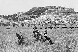
 Sanur around 1908 | |
Location of Sanur within Palestine | |
| Coordinates: 32°21′23″N 35°14′49″E / 32.35639°N 35.24694°E | |
| Palestine grid | 173/195 |
| State | |
| Governorate | Jenin |
| Government | |
| • Type | Village council |
| Population (2017)[1] | |
• Total | 5,036 |
| Name meaning | Sanur, personal name[2] |
Sanur (Arabic: صانور, also spelled Sanour) is a Palestinian village located 26 kilometres (16 mi) southwest of Jenin, in the Jenin Governorate of the State of Palestine. According to the Palestinian Central Bureau of Statistics, Sanur had a population of 4,067 in 2007 and 5,036 in 2017.[1][3] During the late Ottoman era, Sanur served as a fortified village of the Jarrar family and played a key role in limiting the centralized power of the Ottoman sultanate, the Ottoman governors of Damascus and Acre and the Ottoman-aligned Tuqan family of Nablus from exerting direct authority over the rural highlands of Jabal Nablus (modern-day northern West Bank).[4]
- ^ a b Preliminary Results of the Population, Housing and Establishments Census, 2017 (PDF). Palestinian Central Bureau of Statistics (PCBS) (Report). State of Palestine. February 2018. pp. 64–82. Retrieved 2023-10-24.
- ^ Palmer, 1881, p. 190
- ^ "Table 26 (Cont.): Localities in the West Bank by Selected Indicators, 2007" (PDF) (in Arabic). Palestinian Central Bureau of Statistics. 2007. p. 106.
- ^ Doumani, 1995, p. 234
