Back شيلتر آيلاند (نيويورك) Arabic شلتر آیلند ، نیویورک AZB Shelter Island Catalan Шелтер-Айленд (бахархой лерина меттиг, Нью-Йорк) CE Shelter Island (condado de Suffolk) Spanish Shelter Island (New York) Basque شلتر آیلند (حوزه سرشماری)، نیویورک Persian Shelter Island (CDP) French Shelter Island (CDP), New York Malagasy Shelter Island (hrabstwo Suffolk) Polish
Shelter Island, New York | |
|---|---|
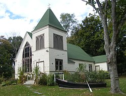
 The Manhasset Church, located within the CDP of Shelter Island. | |
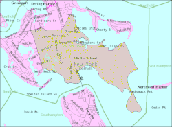
 U.S. Census map of the CDP of Shelter Island | |
| Coordinates: 41°3′44″N 72°19′41″W / 41.06222°N 72.32806°W | |
| Country | |
| State | |
| County | Suffolk |
| Town | Shelter Island |
| Area | |
• Total | 12.80 sq mi (33.14 km2) |
| • Land | 6.55 sq mi (16.97 km2) |
| • Water | 6.24 sq mi (16.17 km2) |
| Elevation | 52 ft (16 m) |
| Population (2020) | |
• Total | 1,602 |
| • Density | 244.43/sq mi (94.38/km2) |
| Time zone | UTC-5 (Eastern (EST)) |
| • Summer (DST) | UTC-4 (EDT) |
| ZIP code | 11964 |
| Area codes | 631, 934 |
| FIPS code | 36-66828 |
| GNIS feature ID | 0965036 |
Shelter Island is a hamlet and census-designated place (CDP) within the Town of Shelter Island in Suffolk County, New York, United States. The population was 1,602 at the time of the 2020 census.
The community is on Shelter Island, between the North and South Forks of Long Island, and is reachable only by ferry. Many of the properties are owned by wealthy New York City residents who use the island as a weekend retreat. Shelter Island is characterized by a quieter and less social lifestyle than that of the nearby Hamptons.
- ^ "ArcGIS REST Services Directory". United States Census Bureau. Retrieved September 20, 2022.
