Back Yilgarn CEB Yilgarn Shire German Comté de Yilgarn French Contea di Yilgarn Italian Shire of Yilgarn Dutch Yilgarn Swedish
| Shire of Yilgarn Western Australia | |||||||||||||||
|---|---|---|---|---|---|---|---|---|---|---|---|---|---|---|---|
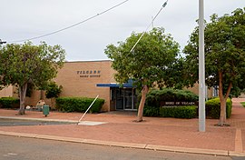
 Yilgarn Shire Office, Southern Cross, 2017 | |||||||||||||||
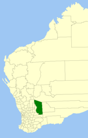
 Location in Western Australia | |||||||||||||||
 | |||||||||||||||
| Population | 1,173 (LGA 2021)[1] | ||||||||||||||
| Established | 1891 | ||||||||||||||
| Area | 30,720 km2 (11,861.1 sq mi) | ||||||||||||||
| Shire President | Wayne Della Bosca | ||||||||||||||
| Council seat | Southern Cross | ||||||||||||||
| Region | Eastern Wheatbelt | ||||||||||||||
| State electorate(s) | Central Wheatbelt | ||||||||||||||
| Federal division(s) | O'Connor | ||||||||||||||
 | |||||||||||||||
| Website | Shire of Yilgarn | ||||||||||||||
| |||||||||||||||
The Shire of Yilgarn is a local government area in the eastern Wheatbelt region of Western Australia about 400 kilometres (250 mi) east of Perth, the state capital. The Shire covers an area of 30,720 square kilometres (11,860 sq mi) and its seat of government is the town of Southern Cross. The main industries within the Shire are mining and farming.
- ^ Australian Bureau of Statistics (28 June 2022). "Yilgarn (Local Government Area)". Australian Census 2021 QuickStats. Retrieved 28 June 2022.