Back ولاية سعرد Arabic Siirt ili Azerbaijani Сіірт (правінцыя) Byelorussian Сыірт (правінцыя) BE-X-OLD Сиирт (вилает) Bulgarian Siirt (proviñs) Breton Siirt (pokrajina) BS Província de Siirt Catalan Siirt (lalawigan) CEB پارێزگای سێرت CKB
Siirt Province | |
|---|---|
 | |
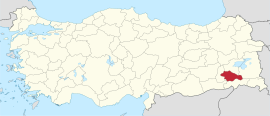
 Location of Siirt Province in Turkey | |
| Country | Turkey |
| Seat | Siirt |
| Government | |
| • Governor | Kemal Kızılkaya |
Area | 5,717 km2 (2,207 sq mi) |
| Population (2022) | 331,311 |
| • Density | 58/km2 (150/sq mi) |
| Time zone | UTC+3 (TRT) |
| Area code | 0484 |
| Website | www |
Siirt Province, (Turkish: Siirt ili, Kurdish: Parêzgeha Sêrtê;[1] Armenian: Սղերդ զավառ) is a province of Turkey, located in the southeast.[2] The province borders Bitlis to the north, Batman to the west, Mardin to the southwest, Şırnak to the south, and Van to the east. Its area is 5,717 km2,[3] and its population is 331,311 (2022).[4] Its capital is Siirt.[2] It encompasses 12 municipalities, 280 villages and 214 hamlets.[2]
The province is considered part of Turkish Kurdistan and has a Kurdish majority.[5][6] The current Governor of the Siirt province is Kemal Kızılkaya.[7]
- ^ "Serokê Parêzgeha Sêrtê yê HDPê Çetîn hat girtin" (in Kurdish). Anadolu Agency. 23 July 2017. Retrieved 27 April 2020.
- ^ a b c "Türkiye Mülki İdare Bölümleri Envanteri". T.C. İçişleri Bakanlığı (in Turkish). Retrieved 19 December 2022.
- ^ "İl ve İlçe Yüz ölçümleri". General Directorate of Mapping. Retrieved 19 September 2023.
- ^ "Address-based population registration system (ADNKS) results dated 31 December 2022, Favorite Reports" (XLS). TÜİK. Retrieved 19 September 2023.
- ^ Watts, Nicole F. (2010). Activists in Office: Kurdish Politics and Protest in Turkey (Studies in Modernity and National Identity). Seattle: University of Washington Press. p. 167. ISBN 978-0-295-99050-7.
- ^ "Kurds, Kurdistān". Encyclopaedia of Islam (2 ed.). BRILL. 2002. ISBN 9789004161214.
- ^ "Yöneticilerimiz". Siirt Valiliği. Retrieved 22 October 2023.