| St Clement's | |
|---|---|
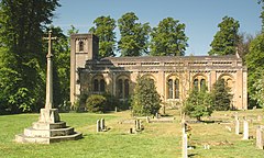
 St. Clement's parish church | |
Location within Oxfordshire | |
| OS grid reference | SP525060 |
| Civil parish |
|
| District | |
| Shire county | |
| Region | |
| Country | England |
| Sovereign state | United Kingdom |
| Post town | Oxford |
| Postcode district | OX4 |
| Dialling code | 01865 |
| Police | Thames Valley |
| Fire | Oxfordshire |
| Ambulance | South Central |
| UK Parliament | |
St Clement's is a district in Oxford, England,[1] on the east bank of the River Cherwell.[2] "St Clement's" is usually taken to describe a small triangular area from The Plain (a roundabout) bounded by the River Cherwell to the North, Cowley Road to the South, and the foot of Headington Hill to the East. It also refers to the ecclesiastical parish of St Clement's which includes some neighbouring areas and is used in the names of local City and County electoral districts.
The area has a multicultural and socially diverse population ranging from owner occupiers, student accommodation and homes in multiple occupation to social housing. A number of properties in the area belong to The Charity of Thomas Dawson (The Dawson Trust) which was founded in 1521 to generate money for the benefit of the people of St Clement's and the parish church.
- ^ Curl, 1977, pages 133–148.
- ^ Hibbert, Christopher, ed. (1988). "St Clement's". The Encyclopaedia of Oxford. Macmillan. pp. 383–384. ISBN 0-333-39917-X.

