Back Штольберг (Гарц) Bashkir Штольберг (Гарц) Byelorussian Щолберг Bulgarian Штольберг (Гарц) CE Stolberg (lungsod sa Alemanya, Saxony-Anhalt) CEB Stadt Stolberg (Harz) German Stolberg (Harco) Esperanto اشتولبرگ (هارتس) Persian Stolberg (Harz) French Stolberg (Harz) Italian
Stolberg | |
|---|---|
 | |
| Coordinates: 51°34′N 10°57′E / 51.567°N 10.950°E | |
| Country | Germany |
| State | Saxony-Anhalt |
| District | Mansfeld-Südharz |
| Municipality | Südharz |
| Area | |
• Total | 67.52 km2 (26.07 sq mi) |
| Elevation | 340 m (1,120 ft) |
| Population (2009-12-31) | |
• Total | 1,286 |
| • Density | 19/km2 (49/sq mi) |
| Time zone | UTC+01:00 (CET) |
| • Summer (DST) | UTC+02:00 (CEST) |
| Postal codes | 06547 |
| Dialling codes | 034654 |
| Vehicle registration | SGH |
| Website | www.stadt-stolberg.de |
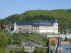
Stolberg (pronounced Stoul-berg ⓘ) is a town (sometimes itself called 'Harz' in historical references) and a former municipality in the district of Mansfeld-Südharz, in the German State of Saxony-Anhalt, Germany. It is situated in the southern part of the Harz mountains, about 27 kilometres (17 mi) west of Sangerhausen, and 13 km (8.1 mi) northeast of Nordhausen. Since 1 September 2010, it has been part of the municipality of Südharz.


