Back Taedong-gang ALS نهر تايدونغ Arabic Тэданган Byelorussian Тедонган (река) Bulgarian ত্যাডং নদী Bengali/Bangla Riu Taedong Catalan Taedong-gang CEB Tedong Czech Afon Taedong Welsh Taedong Danish
| Taedong River | |
|---|---|
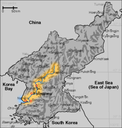
 Map of the Taedong River | |
 | |
| Location | |
| Country | North Korea |
| Physical characteristics | |
| Source | |
| • location | Rangrim Mountains, South Hamgyong |
| Mouth | |
• location | West Korea Bay |
| Length | 439 kilometers (273 mi)[1] |
| Basin size | 20,344 km2 (7,855 sq mi) |
| Taedong River | |
| Chosŏn'gŭl | 대동강 |
|---|---|
| Hancha | 大同江 |
| Revised Romanization | Daedonggang |
| McCune–Reischauer | Taedonggang |
The Taedong River (Korean: 대동강)[a] is a large river in North Korea. The river rises in the Rangrim Mountains of the country's north where it then flows southwest into Korea Bay at Namp'o.[3] In between, it runs through the country's capital, Pyongyang. Along the river are landmarks such as the Juche Tower and Kim Il-sung Square.
The river is 439 kilometres (273 miles) in length, and is generally deep. It is the fifth-longest river on the Korean peninsula and the second-longest in North Korea. Pyongyang is approximately 110 km upstream from the mouth, Sunchon 192 km upstream, and Taehŭng 414 km upstream.[citation needed] Because of its depth, it is widely used for river transport; it is navigable by large ships up to 65 km inland, although most commercial traffic stops at Songrim.
- ^ "Encyclopædia Britannica Online : Taedong River". Encyclopædia Britannica.
- ^ EB (1878), p. 390.
- ^ Suh, Dae-Sook (1987) "North Korea in 1986: Strengthening the Soviet Connection" Asian Survey 27(1): pp. 56-63, page 62
Cite error: There are <ref group=lower-alpha> tags or {{efn}} templates on this page, but the references will not show without a {{reflist|group=lower-alpha}} template or {{notelist}} template (see the help page).